Things to Do in Capitol Reef National Park
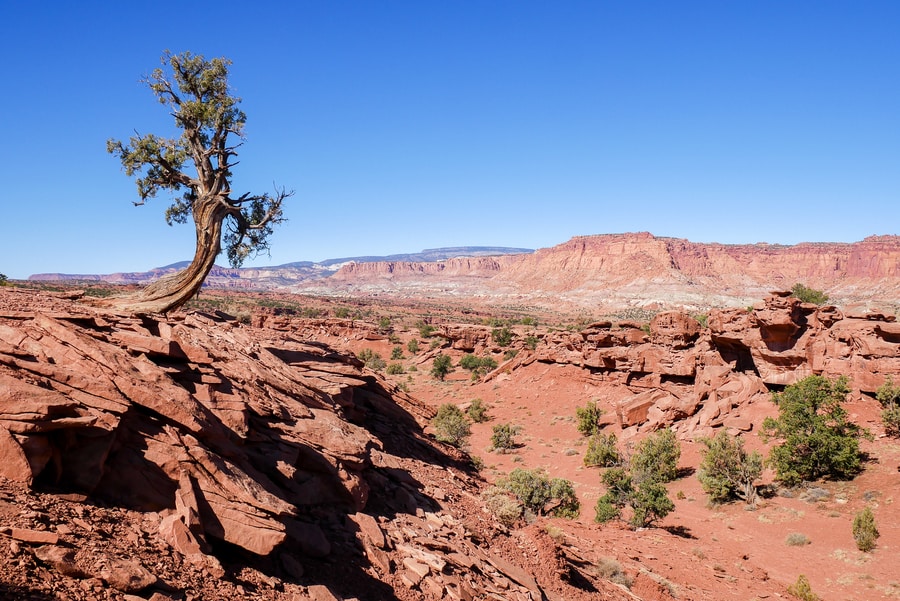
When it comes to red rock landscapes, southern Utah has no shortage of awe-inspiring attractions. The swath of fiery-hued land is so striking that even its lesser-known areas are ripe with places to see.
I became fully cognizant of Utah’s far-reaching splendor while road tripping through Capitol Reef National Park—a place tourists often bypass in lieu of the state’s other more renowned landscapes.
Capitol Reef is the underdog of Utah’s Mighty 5. In fact, the national park receives so little attention that I wondered if it might even be worth visiting. What was there to see and do in Capitol Reef? And why did it always sit in the shadow of its neighbors?
As lovers of offbeat travel, Dan and I decided to explore the national park on a beautiful October weekend. Over the course of two days, we visited the Capitol Reef’s touristy attractions and lesser-known gems.
And in doing so, we discovered one of the most beautiful and underrated corners of the American Southwest.
CAPITOL REEF TOURIST ATTRACTIONS
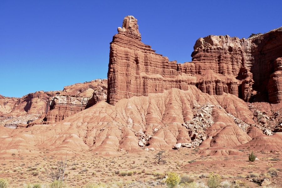
Capitol Reef National Park’s centerpiece is the Waterpocket Fold—a 100-mile-long buckle in the earth’s crust that blocked the westward migration of pioneers in the 1800s. It is said that the formidable wall proved to be a daunting obstacle in the path of explorers (much like a reef blocking a ship’s passage).
Known also for its enormous dome-like rocks that resemble capitol buildings, the national park harbors fantastic hiking trails, rugged 4 wheel drive roads, towering monoliths, and 1000-year-old petroglyph panels.
Capitol Reef National Park isn’t the type of place you can visit in an afternoon. Its disjointed sections require lengthy drives on bumpy roads.
Realizing the area’s lack of infrastructure, Dan and I decided to spend two full days in the park. We crafted an itinerary that would integrate Capitol Reef’s three main sections, while allowing us to visit all the offbeat areas that make the park special.
THE FRUITA DISTRICT
The Fruita District is home to Capitol Reef’s only visitor center. It boasts some of the area’s most incredible red rock landscapes and contains the park’s only network of paved roads. It features apple orchards, shaded picnic areas, scenic drives, and a combination of historical and cultural attractions.
The Fruita District is the most accessible section of Capitol Reef National Park. I read somewhere that it welcomes 99% of the area’s visitors.
Though I’m not sure the statistic is entirely true, I wouldn’t be surprised to learn of its accuracy. The Fruita District was the only place in Capitol Reef where we had to jostle for parking or make way for other tourists on the hiking trails.
-
PANORAMA POINT AND GOOSNECKS OVERLOOK
If you’re driving to Capitol Reef National Park from the direction of Torrey, Panorama Point is the first major turnoff you’ll encounter. The viewpoint lies off Highway 24, near the park’s western entrance.
From Panorama Point, a gravel access road continues for about a mile, before reaching a dead end. At the end of the road, a short uphill walk to Goosenecks Point provides views over Sulphur Creek’s curving river canyon.
-
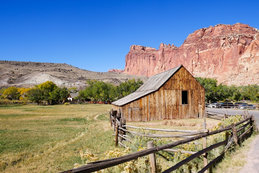
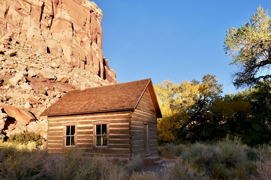
FRUITA HISTORIC DISTRICT
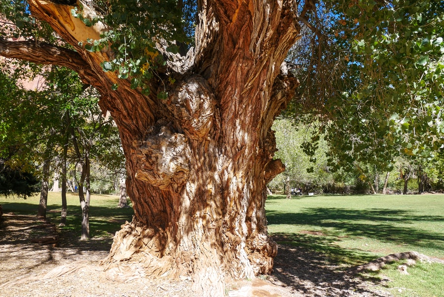
Fruita is a green oasis, where shade-giving cottonwoods and fruit-bearing trees line the Fremont River’s banks. The first Mormon homesteaders arrived in the area in 1879. They settled near the river and established a small community amongst spectacular red rock surroundings.
The historic buildings in Fruita include the Gifford Homestead, a blacksmith shop, and a small one-room schoolhouse that dates back to the late 1800s. The tiny schoolhouse reminded me of the historic one-room Stehekin School that I visited during a trip to Washington’s Lake Chelan.
The oft-photographed Gifford House is an old homestead museum that sells fresh baked goods and preserves made from orchard fruit. Nearby, a grassy lawn amongst ancient cottonwood trees makes for a wonderful picnic area.
The last residents left Fruita in the mid 20th century, but the area’s houses and orchards are still standing. Among the historic buildings in Fruita, the National Park Service maintains fruit trees planted by early settlers.
If you visit between June and October, you can pick ripe fruit from the trees, for free.
-
SCENIC DRIVE
Capitol Reef’s 7.9 mile Scenic Drive splits from Highway 24 in Fruita and winds through the heart of Capitol Reef National Park. Along the way, it allows visitors to see many of the park’s famous formations. It also provides access to popular trailheads and two unpaved offshoot roads.
Scenic Drive features sheer sandstone cliffs in a variety of reddish hues. The area’s layers of shale and rocks have been lifted and folded and carved into the dramatic formations visible today. There are 11 viewpoints marked along the scenic road, providing an overview of the area’s geologic history.
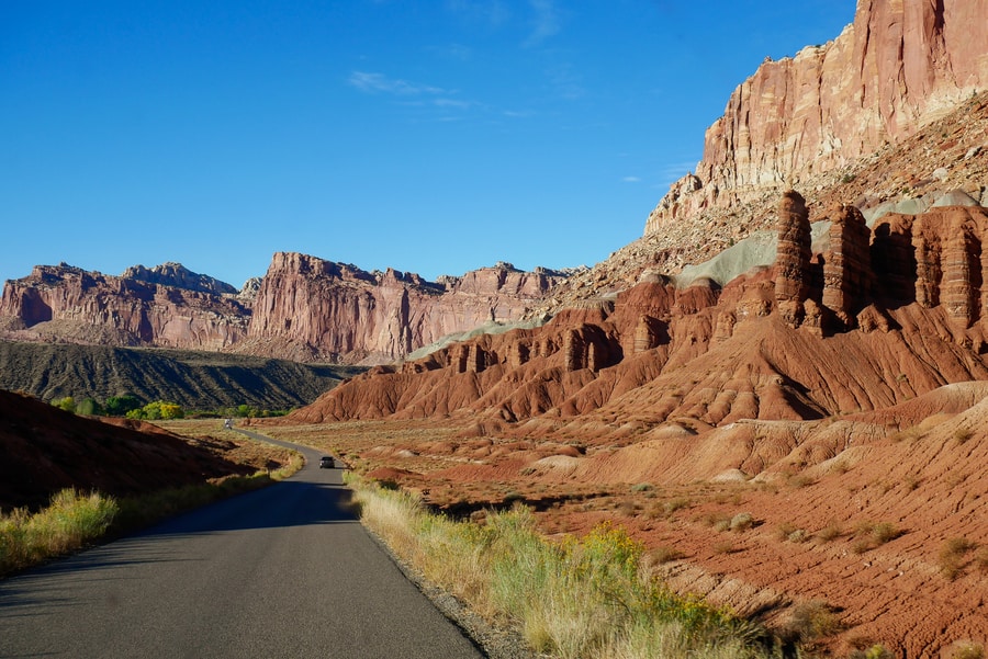
The scenic drive dead-ends at Capitol Gorge Road.
Two unpaved offshoots—Grand Wash Road and Capitol Gorge Road—make for worthwhile detours if weather conditions permit.
-
GRAND WASH
The twisting Grand Wash spur road travels through a narrow, steep-walled canyon. It features sheer sandstone cliffs that contain colorful strata and eroded rock formations.
Beyond the road’s dead-end, hiking paths lead deeper into the canyon and up to Cassidy Arch.
The canyon is subject to dangerous flash floods that often arrive with little warning. Check the forecast before traveling in the area and avoid the wash when storms threaten.
-
CASSIDY ARCH TRAIL
Named after the famous Butch Cassidy, the Cassidy Arch Trail is one of the top hiking destinations in Capitol Reef. The 3.1 mile heavily trafficked path is a spur off of the larger Frying Pan Trail. It provides spectacular aerial views over Grand Wash and leads to one of the most prominent geological features in the national park’s Fruita District.
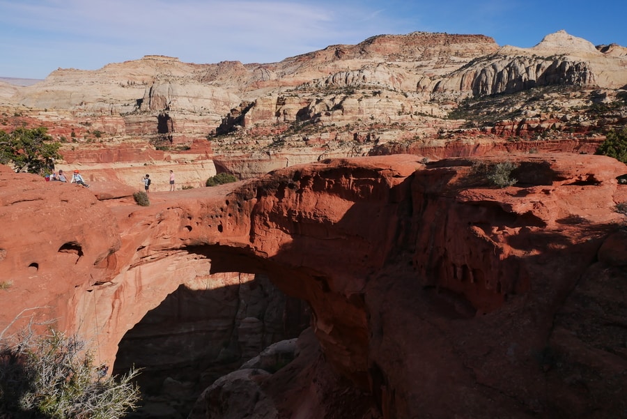
Like Devil’s Bridge in Sedona, it is possible to walk atop the Cassidy Arch Bridge for photo ops. When we visited the rock arch, we even saw people rappelling from the bridge into the canyon below.
-
CAPITOL GORGE
Capitol Gorge Wash is one of many ravines that cuts across the Waterpocket Fold. A geological cousin of nearby Grand Wash, Capitol Gorge played a central role in the park’s human history. In the 1800s, the canyon was the only reliable transit point for Mormon pioneers seeking to pass through the towering, 100-mile long reef.
At the end of the road, a 2 mile hiking trail leads through the narrow gorge. The canyon walls contain a Pioneer Register that has been carved into the sandstone. It contains names of the settlers and miners who traveled through the area nearly two centuries ago.
-
PETROGLYPHS
Mormon settler history is not the only evidence of human habitation within Capitol Reef National Park.
Etched within the area’s red rock walls is evidence of early human activity in the Fruita Valley. Fremont and Ancestral Puebloan people lived in present-day Capitol Reef between 600-1300 A.D. Their rock art tells stories of their hunting patterns, crop cycles, and mythologies.
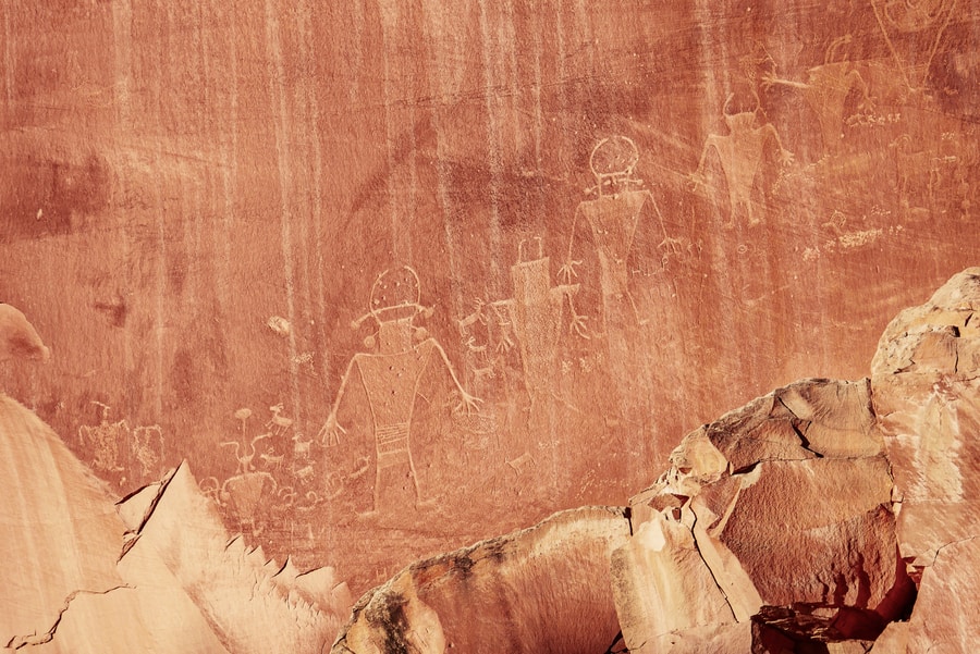
The most pristine example of Capitol Reef petroglyphs can be seen 1.5 miles east of the visitor center, on Highway 24.
-
HICKMAN BRIDGE
Though my two day Capitol Reef itinerary included most of the top things to see and do in the park, I unfortunately did not have the time to hike the Hickman Bridge Trail.
Hickman Bridge is a popular hike in Capitol Reef. The 1.8 mile heavily-trafficked out and back trail features one of the park’s most notable rock arches.
THE CATHEDRAL VALLEY DISTRICT
The Cathedral Valley is a scenic area in the northern reaches of Capitol Reef National Park. A remote and pristine desert, it is characterized by towering sandstone monoliths that are said to resemble cathedrals.
The Cathedral Valley is an enchanting place to visit.
And yet, while it is certainly a must-see southern Utah attraction, it remains almost entirely off the trodden tourist trail.
-
TEMPLES OF THE SUN AND MOON
Visiting the striking Temples of the Sun and Moon is one of the top things to do in Capitol Reef. The rock formations lie just inside the border of the national park, along a treacherous unpaved road.
The sandstone monoliths rise from the desert floor like temples of worship surveying a cityscape. Boasting quiet solitude and scenic backdrops, the Temples of the Sun and Moon are truly magnificent landforms.
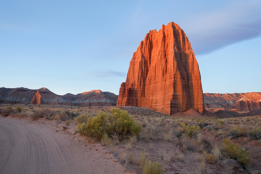
If possible, try visiting the area at sunrise. In the wee hours of the morning, the rising sun paints the rock massif with fiery brushstrokes of red and orange.
Since the landmarks lie at the edge of Bureau of Land Management (BLM)-controlled land, it is possible to camp for free within eyeshot of the monoliths.
-
SCENIC VIEWPOINTS ON THE CATHEDRAL LOOP
Though many tourists who visit Capitol Reef’s iconic Temples of the Sun and Moon choose to drive out and back, the entire 57.6 mile Cathedral Valley Loop is well worth the wear and tear on your car.
The ill-maintained dirt road through the Cathedral Valley offers stunning desert panoramas and views of rock outcrops that erupt from the valley floor. The drive is chock-full of stunning vistas that provide sweeping views over the red rock valley.
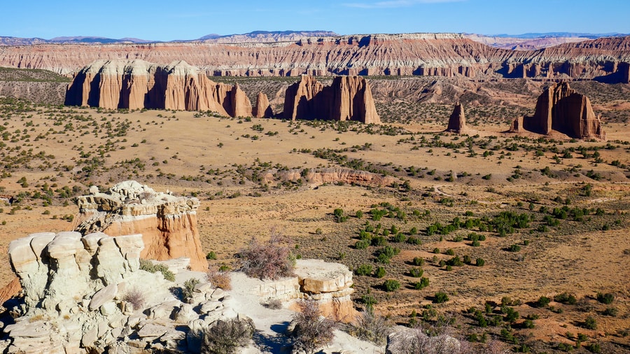
The Cathedral Valley Overlook is among the most impressive viewpoints in Capitol Reef National Park. Other stops of interest include the Gypsum Sinkhole, the Upper Cathedral Valley Overlook, the Upper South Desert Overlook, and the Lower South Desert Overlook.
THE WATERPOCKET DISTRCT
The 100 mile-long Waterpocket Fold is the main reason that Capitol Reef became a national park in 1971.
But unless you drive to the remote Waterpocket District in the southern confines of the park, you won’t get a good idea of what the massive chasm in the earth actually looks like.
So on the afternoon of our second day in Capitol Reef, Dan and I decided to drive to the southern end of the park.
We didn’t exactly know what we would encounter, but we were lured with promises of seldom-trafficked roads and panoramas over the park’s most striking geologic feature.
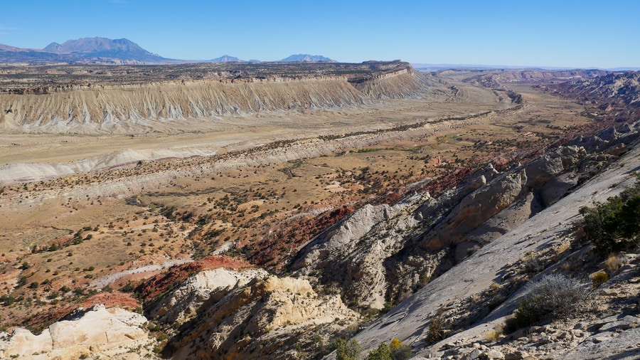
Our drive through the Waterpocket District followed the Notom-Bullfrog Road through the Strike Valley. Then, it veered up the Burr Trail Switchbacks, detoured to the Strike Valley Overlook, and continued toward Highway 12 in the Grand Staircase-Escalante National Monument.
-
BURR TRAIL SWITCHBACKS
After driving through the Strike Valley, Dan and I turned right onto Utah’s spectacular Burr Trail Road. The Burr Trail traverses parts of Grand Staircase Escalante, Capitol Reef, and the Glenn Canyon Recreation Area. Its most defining feature within Capitol Reef National Park is its zigzagging ascent along the Burr Trail Switchbacks.
The hairpin road travels up a daunting rock escarpment that once vexed early travelers who were crossing the plains by stagecoach.
As we drove up the well-maintained gravel road, we stopped frequently to soak in views of the Strike Valley from above.
We couldn’t believe that we had the panoramic vistas entirely to ourselves.
-
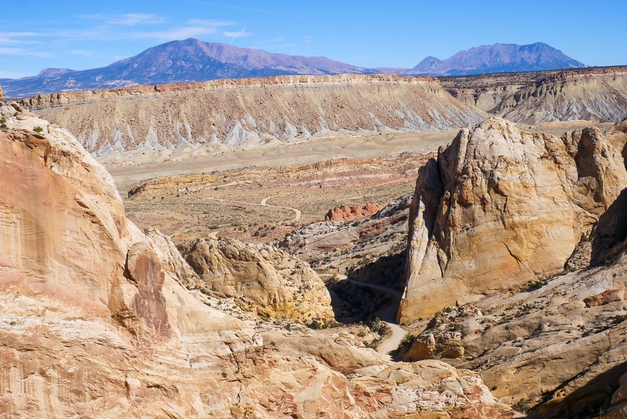
STRIKE VALLEY OVERLOOK
After reaching the top of the escarpment, Dan and I continued down a gravel road to the Strike Valley Overlook.
Soaking in the view from the Strike Valley Overlook is one of the top things to do in Capitol Reef National Park. It is a must-see destination for anyone interested in the area’s fascinating geology.
To reach the Strike Valley Overlook, Dan and I followed a poorly maintained dirt road that veered off the Burr Trail. The road’s driving conditions were treacherous and sometimes downright technical. We were so grateful to have rented a 4 wheel drive vehicle with high clearance and good off-roading capabilities.
Please do not attempt to drive the road in a compact car.
If you wish to see the Strike Valley Overlook during your visit to Capitol Reef, you can always park your vehicle near the turnoff road and hike the six mile roundtrip journey to the viewpoint.
WHERE TO STAY IN CAPITOL REEF
As with many desert parks, camping is the best way to experience Capitol Reef’s night-time splendor. The park is a designated dark-sky preserve. On cloudless nights, it boasts dramatic star-speckled skies that are untainted by light pollution.
There are three campgrounds within Capitol Reef: the 71 spot reservable Fruita Campground, and the primitive first-come first-served Cathedral Valley and Cedar Mesa Campgrounds.
Since much of the national park borders BLM land, finding a camping spot is easy even in peak season. On BLM land, dispersed camping is permitted for free, for up to 14 days at a time.
There are a number of accommodation options in Torrey for travelers who do not wish to camp. Torrey is the gateway to Capitol Reef. The shaded tree-lined town is home to a host of hotels and lodges.
Capitol Reef Resort, Austin’s Chuckwagon Motel, and the Cougar Ridge Lodge all boast great reviews and close proximity to the park’s entrance.
BEST TIME TO VISIT CAPITOL REEF
As with most of the American Southwest, the best time to visit Capitol Reef is during springtime and fall. Soaring summer temperatures can make the area an uncomfortable place to visit in summer months. And come winter, the chill of the high desert means that some activities may be inaccessible.
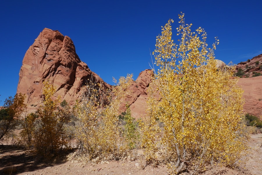
In autumn, the national park’s cottonwood trees erupt in brilliant shades of yellow. It is a spectacular time to visit the park and witness nature’s colorful displays.
Temperature-wise, spring is also a fantastic time to visit Capitol Reef. However, if you are visiting in spring, be sure to check on road conditions before tackling the park’s unpaved roads. Flash floods are real dangers in the area after it rains.
CAPITOL REEF TRAVEL TIPS AND LOGISTICS
- Capitol Reef National Park does not have a designated entrance kiosk. Thus, it is entirely possible to visit some of the most popular areas in the park for free. If you choose to travel along Scenic Drive, you’ll be required to pay $20. The payment is on the honor system. Please do not abuse it.
- There are no places to fuel up in Capitol Reef National Park. If you are planning on driving the Notom-Bullfrog Road or the Cathedral Valley Loop, make sure you fill your car’s gas tank prior to leaving Torrey.
- Please do not attempt to drive to the Strike Valley Overlook without a 4 wheel drive. The road is poorly maintained and requires high clearance. If you get stuck, it could be a while before you encounter help.
****
Capitol Reef National Park is Utah’s redheaded stepchild. Compared to Zion, Bryce, Canyonlands and Arches, it receives hardly any attention. Many people decide to skip Capitol Reef entirely when road tripping through the national and state parks of southern Utah.
And among those who visit, few stray away from the main attractions on Highway 24.
But Capitol Reef—located smack in the heart of red rock country—is a treasure-trove of cliffs, canyons, domes, and bridges.
Just because it doesn’t get the same amount of attention as Utah’s other national parks, doesn’t mean it is any less deserving.
______________________________________________
Did You Enjoy this Guide to Capitol Reef National Park? Pin It!