Driving the Cathedral Valley Loop in Capitol Reef
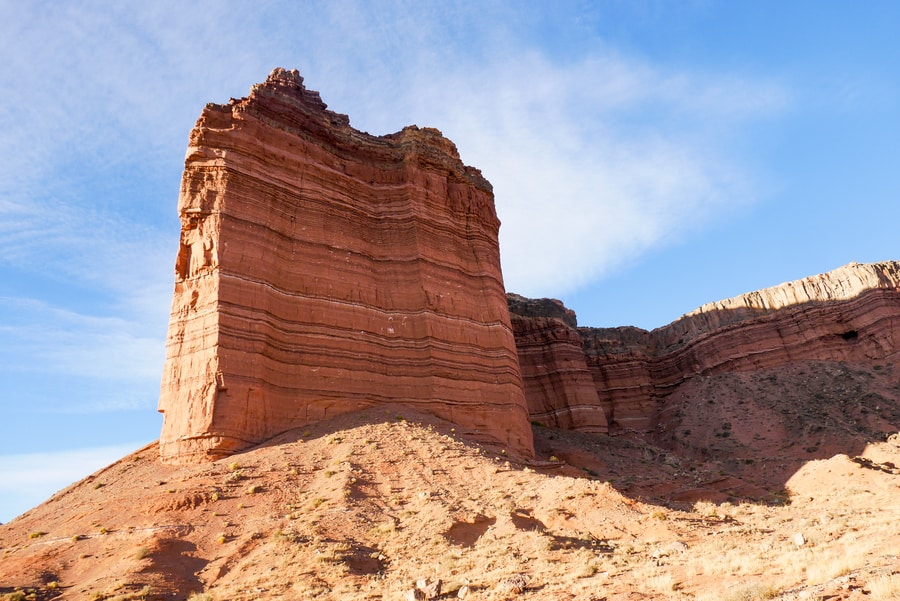
Utah’s Cathedral Valley Loop features towering rock spires, soaring monoliths, colorful painted hillsides, and sweeping desert vistas.
The spectacular 57.6 mile drive weaves in and out of Capitol Reef National Park and contains some of the American Southwest’s most dramatic features.
And yet, despite its beauty, the Cathedral Valley is a place where solitude abounds.
Due to poor roads and a lack of travel infrastructure, only a small fraction of Capitol Reef’s visitors bear witness to the area’s unique landforms. Aside from the occasional jeep rumbling down a sandy road, the area is remarkably silent. Blissfully solitary. Utterly peaceful.
There are no tourist-swamped viewpoints, car-filled parking lots, or overrun hiking trails.
Which makes the area all the more magical for those who choose to visit.
CATHEDRAL VALLEY LOOP VIEWPOINTS
Capitol Reef National Park consists of three main areas: the Fruita District, the Waterpocket District, and the Cathedral Valley District. The Fruita District welcomes a vast majority of the park’s visitors and is home to its most touristy attractions. The latter two are remarkably off-the-beaten-path, despite boasting some of the park’s most dramatic and breathtaking landforms.
When visiting Capitol Reef National Park, most people stick to the attractions near paved Highway 24. Veering off course often requires high-clearance vehicles, a bit of preplanning, and a sense of adventure.
In order to truly witness the national park in all its grandeur, however, steering off the paved road is a definite must. For travelers seeking awe-inspiring desertscapes and solitary vistas, the 57.6-mile Cathedral Valley Loop is an unforgettable experience.
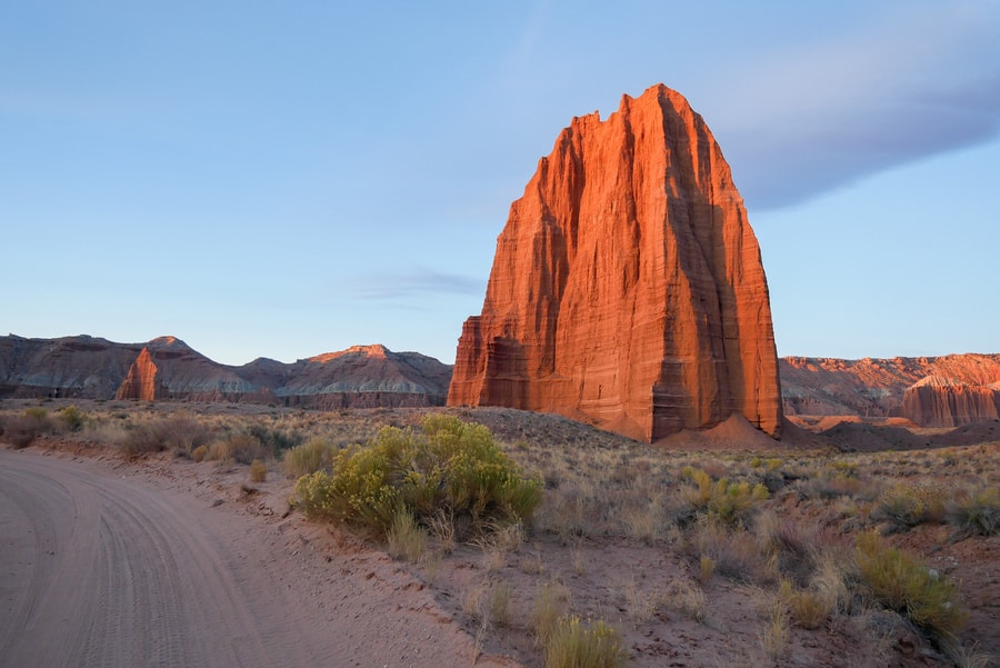
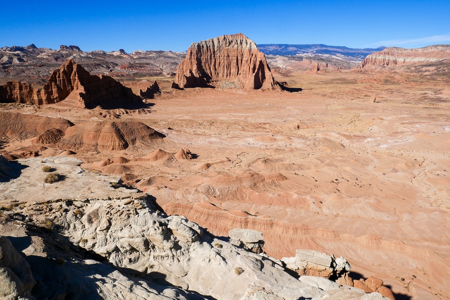
TEMPLES OF THE SUN AND MOON
In Capitol Reef’s Cathedral District, the northern flanks of the Waterpocket Fold give way to sweeping deserts with iconic Estrada sandstone monoliths. Chief among the spectacular outcroppings, are the Temples of the Sun and Moon.
Visiting the striking Temples of the Sun and Moon is one of the top things to do in Capitol Reef. The rock formations lie just inside the border of the national park, along a treacherous unpaved road.
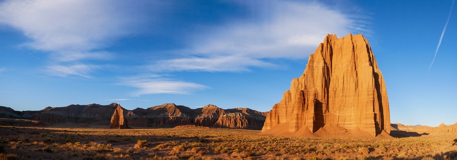
Boasting quiet solitude and scenic backdrops, the Temples of the Sun and Moon are truly magnificent landforms. They erupt from the desert floor, like temples of worship surveying a cityscape.
The rosy-hued monoliths are massive—reaching heights of 500 ft. For most who travel along the Cathedral Valley Loop, they are the primary draw.
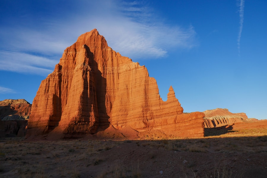
The Cathedral Valley’s temples are especially beautiful in the early morning. At sunrise, light from the east shines on the monoliths and paints them in brushstrokes of fiery red and orange.
GLASS MOUNTAIN
Glass Mountain is a small hill that consists of densely-packed selenite gypsum crystals. It is located near the Temple of the Sun, within the confines of Capitol Reef National Park. The mound’s unique composition formed as a result of crystallizing gypsum.
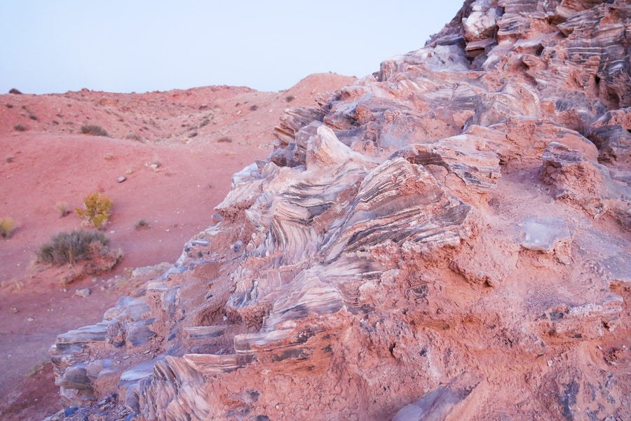
Glass Mountain rises 15 feet above the Lower Cathedral Valley floor. The solubility of the gypsum means that—over an extended period of time—precipitation will most likely dissolve Glass Mountain and transform it into a sinkhole.
GYPSUM SINKHOLE
The Gypsum Sinkhole is a geologic curiosity that is located in the heart of the Cathedral Valley Loop. It provides a snapshot of what Glass Mountain may one day look like.
The sinkhole lies one mile off the main road, among a semicircle of towering cliffs. It measures about 50 ft wide and 200 ft deep.
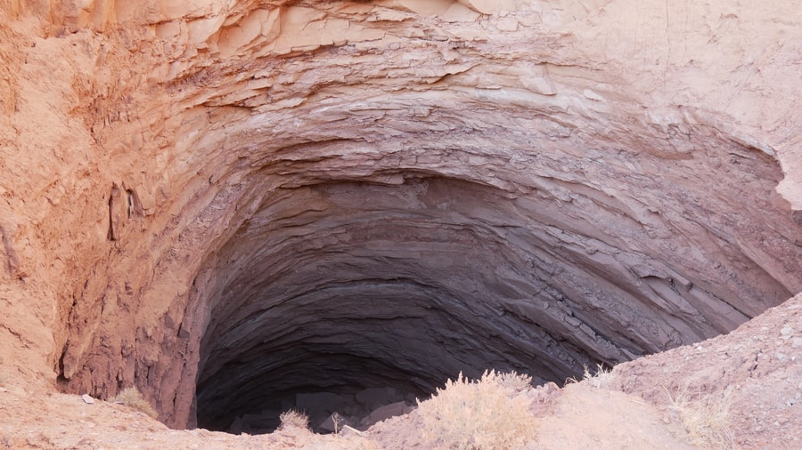
Lack of water aside, the Gypsum Sinkhole in Capitol Reef reminded me of the Bimmah Sinkhole in Oman.
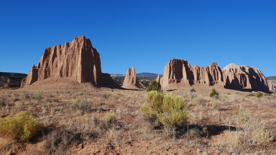
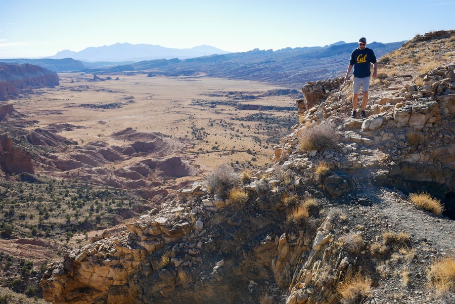
CATHEDRAL VALLEY OVERLOOK
If traveling counterclockwise, the Cathedral Valley Overlook is the first of three spectacular viewpoints along the unpaved 57.6 mile road. It lies past the Cathedral Valley Campground, beyond a series of switchbacks that zigzag up the valley walls.
From the parking area, a short 0.2 mile dirt trail leads to views of the Cathedral Valley from above. The brief hike to the Cathedral Valley Overlook affords aerial views of the enchanting basin and its magical rock spires.
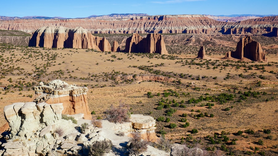
The Cathedral Valley viewpoint showcases a line of rock outcroppings—known as ‘cathedrals’—that vary in size and shape. To their right, stand some of the most colorful fluted Entrada cliffs in the area. To the left, the forested Fishlake Mountains tower above the desert.
UPPER SOUTH DESERT OVERLOOK
Less than a mile from the Cathedral Valley Overlook turnoff, another spur road diverges from Hartnet Road and provides access to the Upper South Desert Overlook.
From the parking area, a 0.2 mile footpath climbs steeply up a rocky outcrop. Atop the outcrop, the trail gives way to 360-degree panoramas.
The Upper South Desert Overlook affords views of the upper reaches of the South Desert—a long, narrow valley that runs parallel to the Waterpocket Fold monocline.
Flanked on all sides by steep cliffs and the Henry Mountains, it is one of the most striking panoramic points in the area.
LOWER SOUTH DESERT OVERLOOK
The Lower South Desert Overlook boasts superb views of sandstone monoliths that erupt from the fiery-hued desert floor. The monoliths—crowned by 500 ft Jailhouse Rock—are spectacular features in a desert that exemplifies the beauty of southern Utah’s national parks.
To reach the panoramic point, veer off Hartnet Road for one mile. Then, follow a level hiking path for about 0.5 miles.
The viewpoint is among the most dramatic in the area and a must-see when traveling the Cathedral Valley Loop.
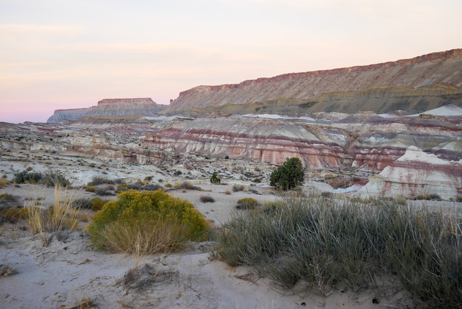
THE BENTONITE HILLS
As Hartent Road leaves the three spectacular viewpoints and heads toward Highway 24, it passes through a colorful patch of rounded Bentonite hills. The rolling hills make for a worthwhile photo stop along the Cathedral Valley Loop.
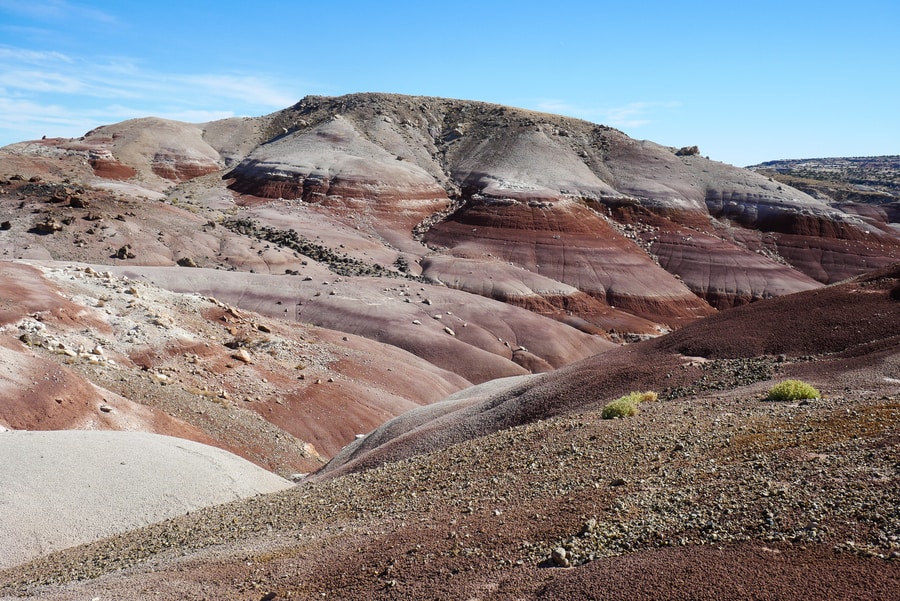
The Bentonite Hills formed millions of years ago, from volcanic ash. They boast stratified layers of grey, pink, brown, red, and burgundy.
Visually, the Bentonite Hills look a lot like the Painted Hills in Central Oregon‘s John Day Fossil Beds National Monument.
THE WATER WELL OASIS
Dan and I stumbled across a water well oasis shortly after passing by the Bentonite Hills. The abandoned well came as a bit of a surprise, since it wasn’t marked on our map and didn’t contain an informational placard.
The small oasis sits among a lush patch of green grasses. Several trees have grown up around the well’s bathtub-like trough. Beside it, an abandoned drilling rig and 1930s-era truck make for a nostalgic Western photo opportunity.
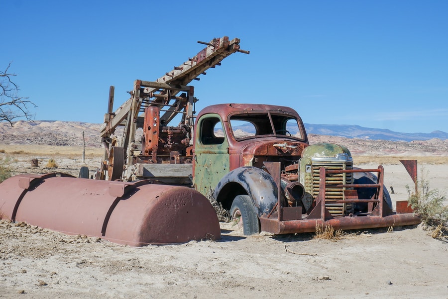
After regaining cell signal, I decided to research the well. One article I came across stated that a farmer had dug it in order to feed his cows.
Since I can no longer find the article, I don’t know how to corroborate that claim. Nor can I find an explanation for the rusty truck that lies half-buried in the sand.
CAMPING IN THE CATHEDRAL VALLEY
Along its course, the Cathedral Valley Loop enters and exits the boundaries of Capitol Reef National Park. When it travels outside the park’s borders, it passes through Bureau of Land Management (BLM)-controlled land. Dispersed camping is permitted on BLM land for free, for up to 14 days.
The Cathedral Valley Campground is the only established camping facility in Capitol Reef’s northern reaches. It is located about halfway along the loop road, near the spectacular cluster of overlooks.
For those who are not interested in camping, Cainville’s Rodeway Inn is the closest accommodation option to the Cathedral Valley. Additional lodging options are located in Torrey.
CATHEDRAL VALLEY MAP & DRIVING ROUTE
We found the entire Cathedral Valley Loop to be full of surprises—from magnificent landforms, to jaw-dropping panoramic vistas, to rolling pastel-colored hills.
The complete Cathedral Valley Loop is 70 miles, starting and ending at Harnet Road. Aside from a short paved portion along Highway 24, it mostly follows a 57.6 mile dirt track.
Travelers in a hurry can drive the route in about 3-4 hours. If possible, however, I recommend camping near the Temples of the Sun and Moon and exploring the area over the course of an entire day.
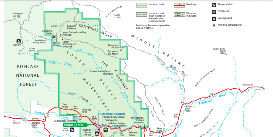
Many people suggest beginning the loop at the junction of Hartnet Road and Highway 24. The clockwise drive begins with a fording of the Fremont River. The water is usually no more than a foot deep at the crossing location, but 4 wheel drive vehicles with high clearance are still recommended.
We did the loop counterclockwise and had no problem whatsoever fording the river. In fact, we found the river ford to be far less stressful than the deep pockets of sand we encountered along Cainville Wash Road.
Regardless of the route you take, be sure to check on weather conditions. To do so, you can stop by the Capitol Reef Visitor Center, or call (435) 425-3791.
****
Southern Utah’s Cathedral Valley is a land of awe-inspiring rock formations and dramatic desert vistas.
A rugged backcountry protected by Capitol Reef National Park and the Bureau of Land Management, it is a sweeping expanse that beckons adventure-lovers and solitude-seekers.
The Cathedral Valley is an iconic landscape that has somehow managed to avoid becoming an Instagram sensation. It remains a quiet escape, despite its crowd-pleasing visual appeal.
I believe we have poor infrastructure and treacherous roads to thank.
__________________________________________________
Did You Enjoy this Guide to Southern Utah’s Cathedral Valley Loop? Pin It!