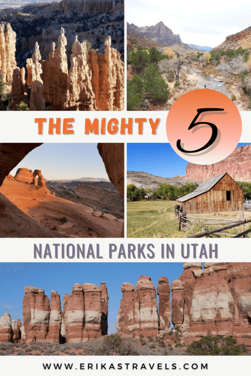
The Mighty 5: A Guide to Utah’s National Parks
Southern Utah is an expansive desert wilderness that beckons travelers from around the world. One of nature’s great canvases, it features chiseled canyons, red rock hoodoos, delicate arches, soaring cliffs, and lonely unpaved roads.
I’ve said it often and I’ll say it again: There’s no place quite like southern Utah.
While the United States has its fair share of breathtaking landscapes, southern Utah is truly out of this world. The legendary area—home to some of the American Southwest’s signature attractions—boasts some of the most iconic desertscapes on Earth.
Its swath of red desert encompasses no less than five stunning national parks.
And while each is truly unique and deserving of individual praise, together Utah’s national parks comprise the legendary Mighty 5.
THE MIGHTY 5 IN UTAH
Utah’s Mighty 5—Zion, Bryce, Capitol Reef, Canyonlands, and Arches—are certainly worthy of the hype they receive. While the parks each contain striking red rock landscapes, they are all completely unique in their own way.
Each Utah park anchors a travel region that beckons adventurers and photographers. In Arches, stone bridges litter a juniper-clad desert. In nearby Canyonlands, water and erosion have carved out a sprawling landscape of pinnacles and chiseled ravines. In Capitol Reef, little-known backroads give way to epic lonely vistas. In Bryce, fairy tale hoodoos inspire photographers in droves.
And finally, in Zion, Utah’s red rock grandeur culminates in one of the world’s most awe-inspiring destinations.
While some might argue about which Utah national park is the most beautiful, one thing is for certain: Collectively, the Mighty 5 have a nickname that is well-suited.
OUR MIGHTY 5 ROAD TRIP
We visited Utah’s National Parks over the course of two road trips. Collectively, these short vacations consisted of two days in Zion, one day in Bryce, two days in Capitol Reef, one day in Arches, and two days in Canyonlands.
On our first trip, we spent a weekend exploring Capitol Reef with a Toyota 4Runner. The vehicle allowed us to travel the national park’s treacherous roads with little fear of getting stuck.
One month later, we returned to southern Utah with the intention of visiting the other national parks. We wanted more freedom to explore without having to worry about food and accommodation, so we decided to rent a campervan with Traveller’s Autobarn. The budget campervan rental allowed us to sample van-life for less than the price of a car rental.
Most people access the area via Las Vegas (2.5 hours from Zion, 6.5 hours from Arches) or Salt Lake City (3+ hours from each of the Mighty 5). When we visited Capitol Reef, we used Salt Lake City as our gateway. On our longer road trip, we chose to fly in and out of Las Vegas.
A mighty 5 road trip takes at least one week, end to end. A minimum of ten days would be ideal. Anything less than a week means being forced to skip out on some of the most awe-inspiring attractions in the United States.
ARCHES NATIONAL PARK
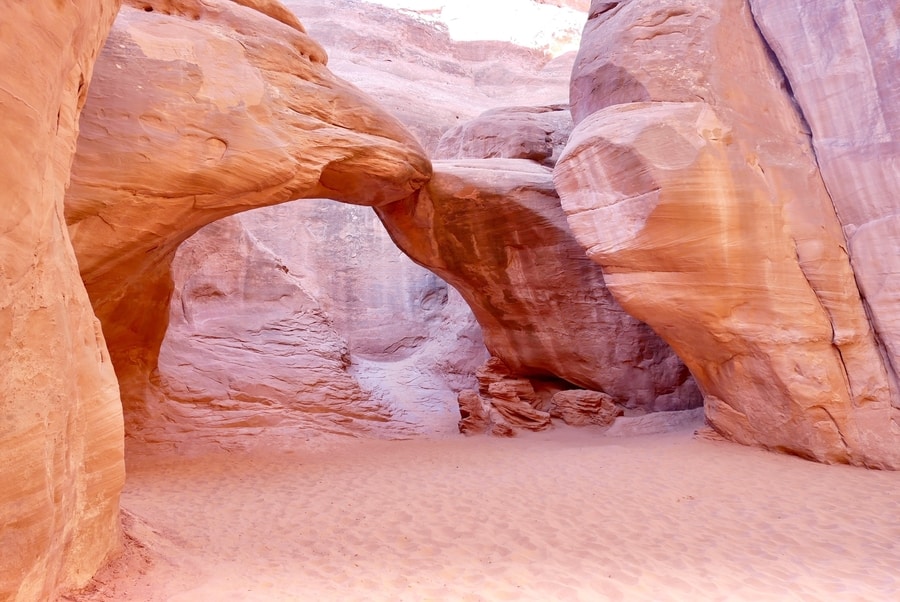
Arches National Park is a beloved Utah tourist destination. A masterpiece of nature, it is renowned the world over for its delicate stone gardens. The national park’s giant sandstone arcs lie beneath the gaze of the La Sal Mountains. While the entire area is a red rock paradise, the natural rock arches are its primary draw.
In fact, its signature arch is so universally lauded, that it has become a defining symbol of the American Southwest.
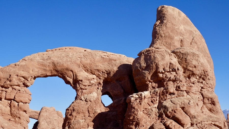
ARCHES NATIONAL PARK WINDOWS SECTION
The Windows Section is one of three main areas in Arches National Park. It is home to a dense concentration of arches that stand within eyeshot of each other.
A popular short one-mile loop in the Windows Area visits North Window, South Window, and Turret Arch.
Across the parking lot, cavernous Double Arch—the park’s tallest—is another site worth visiting.
DEVIL’S GARDEN
Devil’s Garden is home to Arches National Park’s longest official hiking trail. It lies at the very end of the Arches National Park Scenic Drive.
The hike through Devil’s Garden winds between towering rock spires and passes by Landscape Arch—the world’s longest natural bridge.
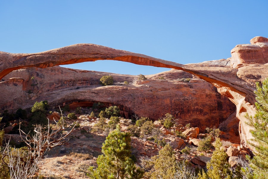
Devil’s Garden Loop is the park’s most adventurous trek. For those looking to lace up their hiking boots, it brings a slew of rewards. In just under eight miles, the trail features no less than eight spectacular natural arches.
DELICATE ARCH SECTION
Even if you’re unfamiliar with the beauty of Utah’s national parks, I’m sure you’ve seen photos of Delicate Arch. It is one of the most iconic landmarks in the US National Parks System.
The best way to experience Delicate Arch is by hiking the scenic three-mile trail to its base.
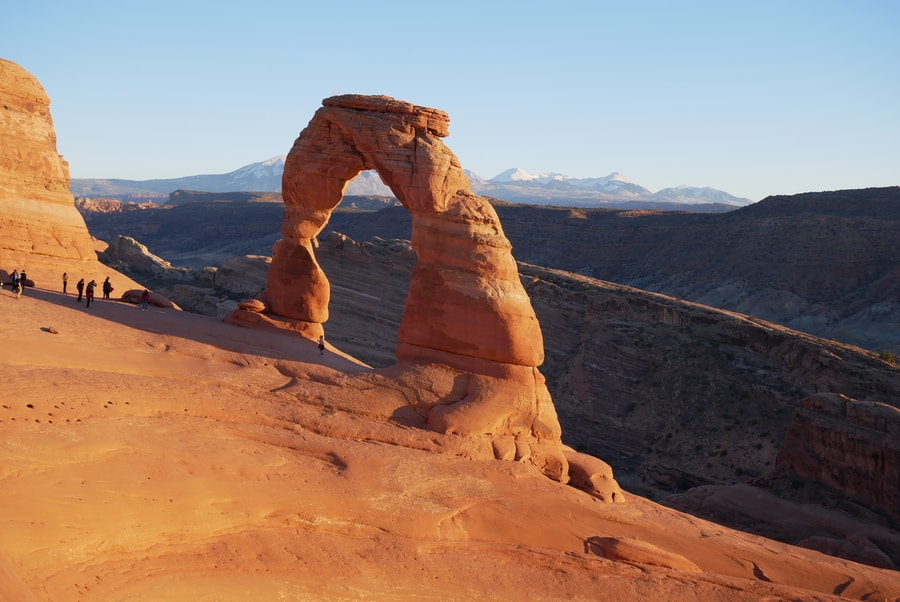
The upside-down U shaped arch is the national park’s top attraction. It is the largest free-standing Arch in the park.
The Delicate Arch Trail may be packed with tourists, but it is popular for a reason. If you only have limited time to spend in the Utah park, then hiking to the exquisite stone arch should be your #1 priority.
PRACTICAL TIPS FOR VISITING ARCHES
Arches National Park is compact and easy to navigate. Like Bryce, it features tons of roadside viewpoints and short hiking trails that make it possible to see the best of the area in a limited timeframe.
-
ARCHES NATIONAL PARK ENTRANCE FEE
Admission to Arches National park is good for seven days and costs $30 per vehicle. Travelers intent on visiting both Arches and Canyonlands may want to consider the $55 Southeastern Utah Parks Pass (valid for one year).
If you’re planning on visiting more than three national parks in Utah, then an Annual Interagency Pass is your most cost-effective bet.
-
HOTELS NEAR ARCHES
When visiting Arches, most travelers choose to stay in nearby Moab. The town is Utah’s gateway to both Arches and Canyonlands.
Moab has a wide variety of accommodations that suit all types of budget and lodging preferences. Hotels with particularly good reviews include the Mainstay Suites (budget), the Hoodoo Moab (mid-range) and the Sunflower Hill Inn (upper-end).
-
CAMPING IN ARCHES NATIONAL PARK
Devil’s Garden Campground is the only lodging option within Arches National Park. A full-service camping area, it lies situated among spectacular rock fins.
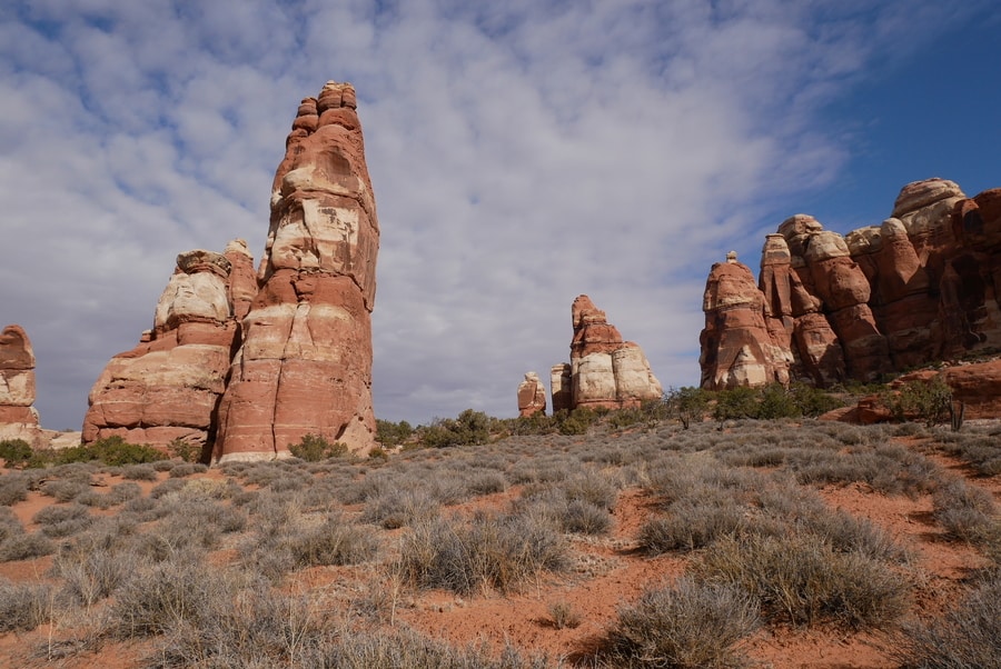
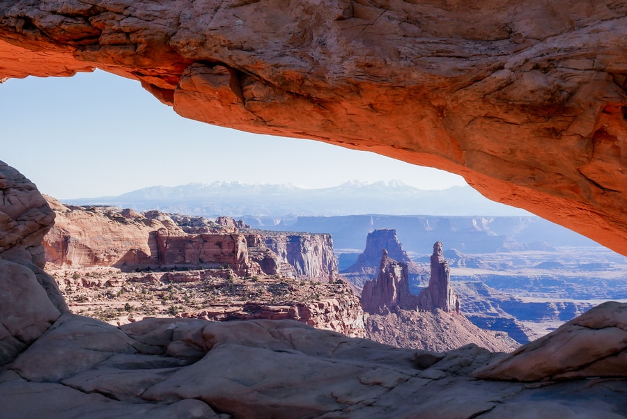
CANYONLANDS NATIONAL PARK
Canyonlands National Park boasts some of the most enthralling and underrated vistas in all of Utah. Within its 520 square mile expanse, it contains winding river canyons, towering rock spires, white-rimmed cliffs, and ancient Native American settlements.
The Colorado and Green rivers form a Y that divides Canyonlands into four distinct districts: The Island in the Sky, The Needles, The Maze, and Horseshoe Canyon.
Each district is independent from the other and contains its own set of must-see attractions.
ISLAND IN THE SKY DISTRICT
Canyonlands’ Island in the Sky offers breathtaking views over the Colorado and Green rivers. Its roadside pullouts lie along a Y-shaped ribbon of pavement that traces the entire length of the plateau.
In the Island in the Sky, majestic overlooks provide accessible aerial vistas of the sprawling red rock maze.
From the visitor center, the national park road leads past numerous overlooks and trailheads, toward Grand Viewpoint. Chief places of interest include the White Rim Overlook and Buck Canyon Overlook.
A secondary branch off the main road leads toward Upheaval Dome. Notable stops along the way include the Aztec Ruins and Whale Rock.
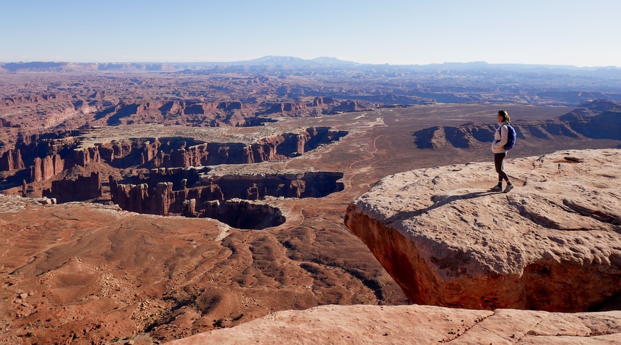
The Island in the Sky’s panoramic viewpoints bring visitors face-to-face with the area’s sheer walls and white-tipped cliffs. Every overlook in the district offers a different birds-eye vantage point over the chiseled desertscape.
THE NEEDLES DISTRICT
The Needles District is famous for its wall of stone pillars that jut skyward like blunted needles in a vast pincushion. Among its towering rock gardens, the area contains some of the best hiking trails in southern Utah.
Although it isn’t as heavily trafficked as Island in the Sky, the hiker’s wonderland boasts bewitching vistas, diverse topography, and unforgettable trails.
Top hikes in The Needles include the Chesler Park Loop and the Druid Arch Trail.
THE MAZE AND HORSESHOE CANYON
The Maze and Horseshoe Canyon—two areas of the park that I have yet to explore—are remote and seldom-visited. They require 4×4 vehicles and loads of time.
PRACTICAL TIPS FOR VISITING CANYONLANDS
Canyonlands is huge. Even with two jam-packed days of sightseeing, Dan and I only scratched the surface. If you’re looking to visit the park in one day, Island in the Sky provides the easiest access to viewpoints. Alternatively, if you’re a lover of meandering hikes, The Needles affords views of otherworldly terrain.
Beyond its two most popular sections, Canyonlands is America at its most wild and inaccessible.
-
CANYONLANDS ENTRANCE FEE
Admission to Canyonlands National Park costs $30. For travelers wishing to spend more time in the area, a Southeast Utah Parks pass may be a more effective purchase. It costs $55, is valid for one year, and allows for unlimited entrances to both Arches and Canyonlands.
Of course, I always advocate for the $80 Interagency Annual Pass. It provides the most far-reaching access to America’s federal lands.
-
HOTELS NEAR CANYONLANDS
Most visitors to Canyonlands will choose to stay in Moab—southeast Utah’s premier tourism hub. As a gateway to the region’s attractions, Moab has a long list of fantastic places to stay. These places suit a wide array of travel styles and budgetary constraints.
Top-rated hotels in Moab include the Castle Valley Inn and Sunflower Hill Inn.
-
CAMPING IN CANYONLANDS NATIONAL PARK
In the Island in the Sky District, the Willow Flat Campground has 12 first-come first-served spots and is open year-round. Nearby, Dead Horse Point State Park contains two additional established camping areas.
The Needles Campground has 26 designated spaces and costs $20 per night.
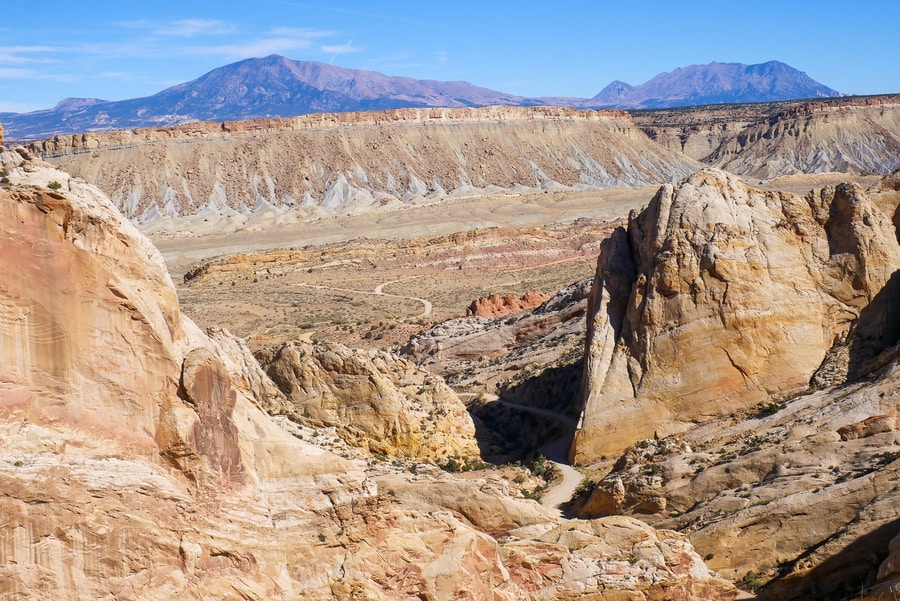
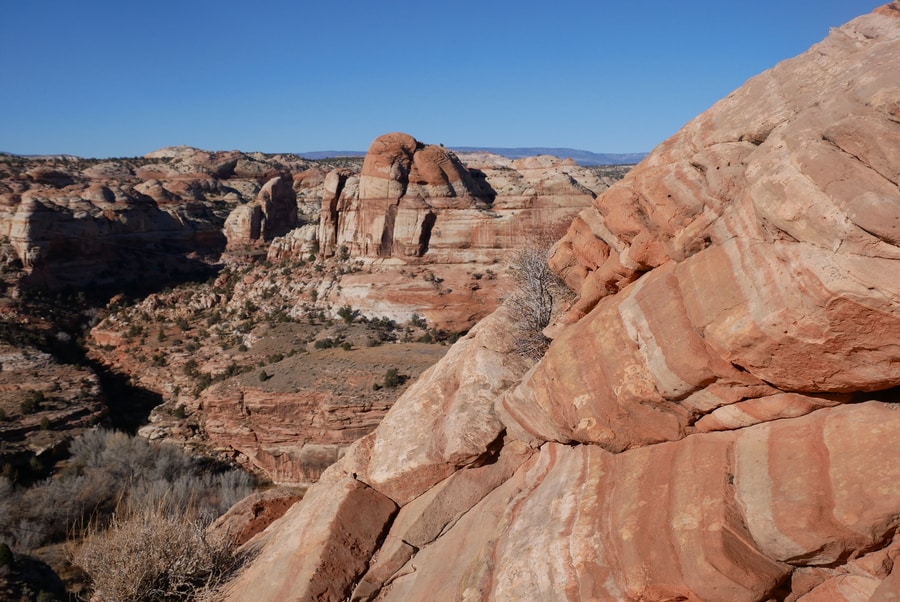
CAPITOL REEF NATIONAL PARK
Though Capitol Reef is Utah’s least-visited national park, its scenery is no less awe-inspiring. Most people limit their visits to the Capitol Reef Scenic Drive and stop by the attractions along Highway 24.
But the park is so much more than a drive-through destination or quick pit-stop.
Capitol Reef is steeped in history and geological importance. Top things to do in Capitol Reef include visiting the orchards in the Fruita District and going off-grid to the park’s Cathedral Valley and Waterpocket Districts
THE FRUITA DISTRICT
The Fruita District is home to the Capitol Reef Visitor Center. It is the most highly-trafficked area in the park and contains Capitol Reef’s only network of paved roads.
The 7.9 mile Scenic Drive splits from Highway 24 in Fruita and winds through the heart of Capitol Reef National Park. Along the way, it allows visitors to see many of the park’s famous formations. It also provides access to popular trailheads and two unpaved offshoot roads.
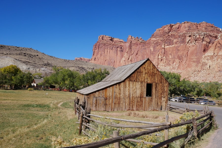
Capitol Reef’s Fruita District features apple orchards, shaded picnic areas, scenic drives, and a combination of historical and cultural attractions. Top places of interest include the Gifford Homestead, the Grand Wash Road, and Capitol Gorge.
CATHEDRAL VALLEY LOOP
The Cathedral Valley is a scenic area of Capitol Reef that lies north of Highway 24. A remote and pristine desert, it is characterized by cathedral-like monoliths that erupt from the desert floor.
The Cathedral Valley is among the most enchanting areas of the park.
And yet, while it is undoubtedly a must-see attraction, it remains almost entirely off the trodden tourist trail.
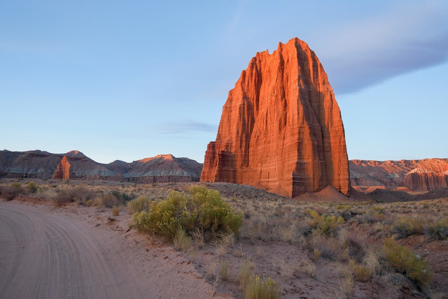
Visiting the striking Temples of the Sun and Moon is the highlight of the Cathedral Valley Loop. The rock formations lie just inside the border of the national park, along a treacherous sandy road.
Other must-see destinations along the loop include the Cathedral Valley Overlook, the Upper and Lower South Desert overlooks, and the Bentonite Hills.
WATERPOCKET DISTRICT
The Waterpocket Fold is the main reason that Capitol Reef became a national park in 1971.
A 100 mile buckle in the earth’s crust, it is a geological curiosity that once blocked the westward migration of pioneers.
The Strike Valley Overlook provides the best views over the park’s extensive wrinkle. It is well worth the detour, despite its somewhat questionable access road.
From Fruita, the drive to the Waterpocket District follows the Notom-Bullfrog Road through the Strike Valley. Then, it veers onto the Burr Trail Road, ascends a series of hairpin switchbacks, detours to the Strike Valley Overlook, and continues toward Grand Staircase-Escalante National Monument.
PRACTICAL TIPS FOR VISITING CAPITOL REEF NATIONAL PARK
While Capitol Reef is Utah’s second largest national park by area, most travelers limit their visits to the Fruita District due to easier accessibility. In other areas of the park, infrastructure is rudimentary at best (think potholed dirt roads, pockets of sand, and river crossings without bridges).
If you’re planning on visiting all three areas of the park, make sure you have access to a 4 wheel drive with high clearance.
-
CAPITOL REEF ENTRANCE FEE
Capitol Reef operates on the honor system. Unlike the other national parks in Utah, Capitol Reef does not have a designated fee collection kiosk at its entrances.
The park’s Scenic Drive costs $20 and is payable at the visitor center. There are no fees associated with traveling the Cathedral Valley Loop or Burr Trail Road.
-
HOTELS NEAR CAPITOL REEF
Torrey is the gateway to Capitol Reef. The shaded tree-lined town is home to a host of hotels and lodges.
Capitol Reef Resort and the Cougar Ridge Lodge both have great reviews and lie within close proximity to the park’s entrance.
-
CAMPING IN CAPITOL REEF NATIONAL PARK
Capitol Reef houses three campgrounds: the 71 spot reservable Fruita Campground, and the primitive first-come first-served Cathedral Valley and Cedar Mesa campgrounds.
Additionally, since much of the national park borders BLM land, finding a camping spot is easy even in peak season. On BLM land, dispersed camping is permitted for free, for up to 14 days at a time.
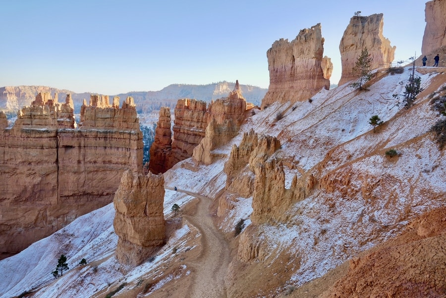
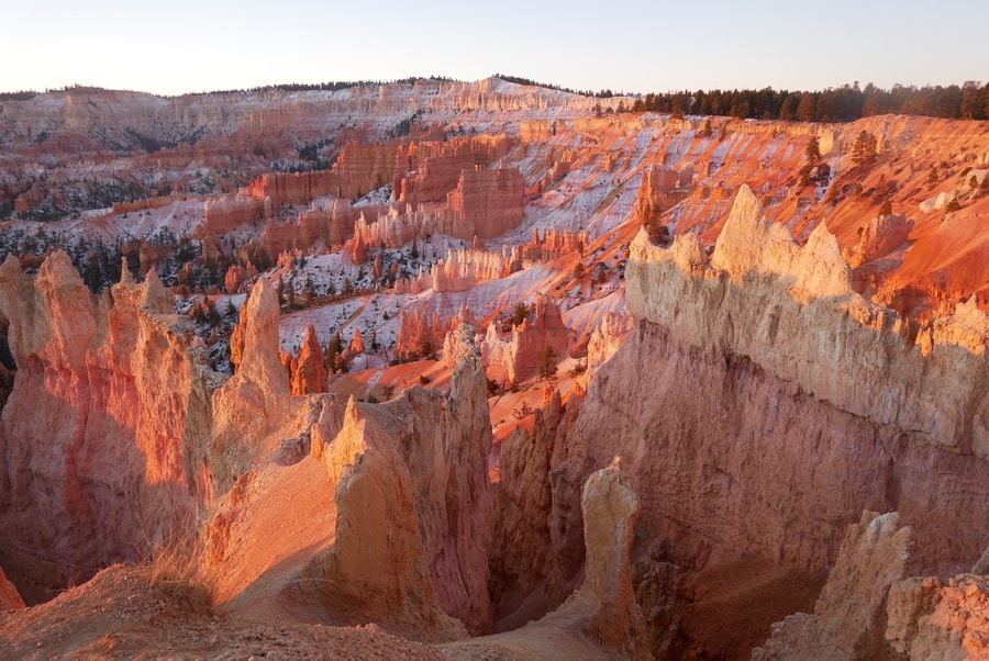
BRYCE CANYON NATIONAL PARK
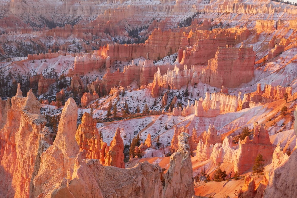
Visiting Bryce Canyon is like setting foot in a fairy tale. Renowned for its forest of otherworldly rock spires, the park’s ethereal landscape is nothing short of breathtaking.
Bryce’s spire-clad environment is utterly unique and unforgettable. It is an artist’s inspiration; a photographer’s dream.
The national park’s must-see viewpoints line the eastern edge of a 20 mile scenic drive that follows the canyon rim. Near the park entrance, viewpoints showcase the striking Bryce Canyon Amphitheater. Toward the end of the road, panoramic points offer more intimate glimpses into the canyon’s lesser-known reaches.
BRYCE CANYON AMPHITEATER
The Amphitheater is the centerpiece of Bryce Canyon National Park. The Amphitheater viewpoints include Sunrise Point, Sunset Point, Bryce Point, and Inspiration Point. A rim trail connects the viewpoints and provides sweeping aerial panoramas of the canyon and its jagged hoodoos.
Sunrise Point, near the park’s visitor center, boasts postcard-worthy views of the Silent City and Thor’s Hammer. The colors at Sunrise Point are among the most vivid in the park.
The Navajo Loop/Queen’s Garden combination trail is one of the top hikes in Bryce. It leaves from Sunrise Point and descends into a spectacular area of jagged rock pinnacles, before making its way back up to Sunset Point.
BRYCE CANYON SCENIC DRIVE
For travelers with a bit more time, the viewpoints along the Bryce Canyon Scenic Drive are likewise compelling. They offer intimate glimpses into more off-the-beaten-path corners of the national park.
Chief places of interest along the Bryce Canyon Scenic Drive include the Natural Bridge Viewpoint, Swamp Canyon, and Rainbow Point.
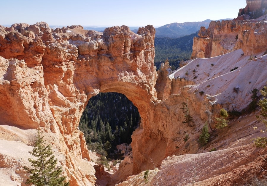
While its aerial views are somewhat less dramatic than those in the Amphitheater, the stops along Bryce Canyon’s scenic drive highlight the area’s varied geology. Carpets of ponderosa pines contrast against red rock spires. In the distance, the 11,328 ft Aquarius Plateau looms above Utah’s nearby Grand Staircase-Escalante.
PRACTICAL TIPS FOR VISITING BRYCE
Logistically, Bryce Canyon is easy to navigate. As the smallest national park in Utah, its top attractions can be easily visited in one day. The park hugs a 20 mile scenic road that is open to both shuttle service and individual vehicle traffic.
-
BRYCE CANYON ENTRANCE FEE
Entrance to Bryce Canyon costs $35 per vehicle. The pass includes unlimited entrances and is valid for one week. If traveling to Bryce as part of a multi-park road trip, however, I recommend purchasing the Interagency Pass for $80.
-
HOTELS NEAR BRYCE CANYON
The Lodge at Bryce Canyon is the only accommodation option within the confines of the national park. The historic hotel offers guest suites, motel rooms, and cabins that are within walking distance of the Amphitheater.
Near the park’s entrance, the small town of Bryce has a handful of places to stay—including Ruby’s Inn and the Luxe Bryce Canyon Home.
-
CAMPING IN BRYCE
Bryce Canyon National Park has two campgrounds that are located within close proximity of the Bryce Amphitheater. North Campground operates on a first-come first-served basis, while Sunset Campground accepts reservations during peak season.
ZION NATIONAL PARK
Zion National Park is often considered to be the pinnacle of Utah’s grandeur. The park features sheer red rock cliffs, sweeping canyon vistas, and some of the best hiking trails in the United States.
The spectacular park encompasses 232 square miles of pure awesomeness. A red rock wonderland, it is home to narrow sandstone canyons, soaring red cliffs, and pockets of emerald vegetation.
From its intoxicating colors to its lofty vistas that overlook the meandering Virgin River, the Utah park brims with bucket-list backdrops.
THE ZION CANYON
Zion Canyon is the national park’s beating heart. Its hiking trails afford some of the most iconic views in Utah.
Zion’s popularity comes at a price, however. The canyon can get incredibly crowded. In fact, the area is so popular that the park implemented a mandatory shuttle system in order to alleviate congestion.
Still, the red rock canyon is a highlight of Utah’s Mighty 5 and a must-visit bucket list destination for nature-lovers.
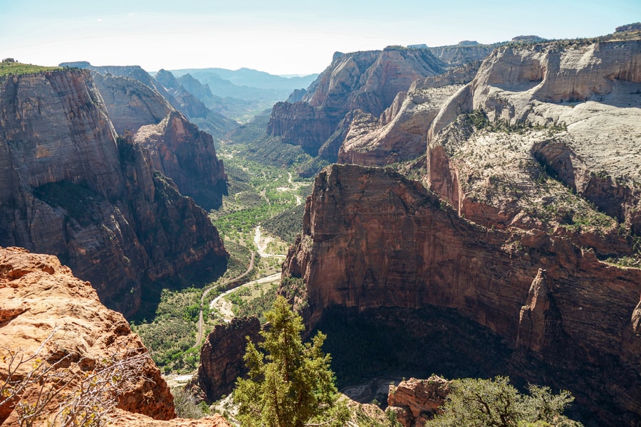
Popular hikes in the Zion Canyon include Angel’s Landing, Observation Point, and the Narrows.
THE KOLOB CANYONS
The Kolob Canyons sees only a fraction of Zion National Park’s visitors. Yet the underrated area is no less impressive than the park’s more touristy destinations.
The Kolob Canyons showcases a series of parallel fissures that are ripe for exploring. These fissures, or ‘finger canyons,’ conceal lesser-known hiking trails that lead to oases, natural arches, and unique sandstone formations.
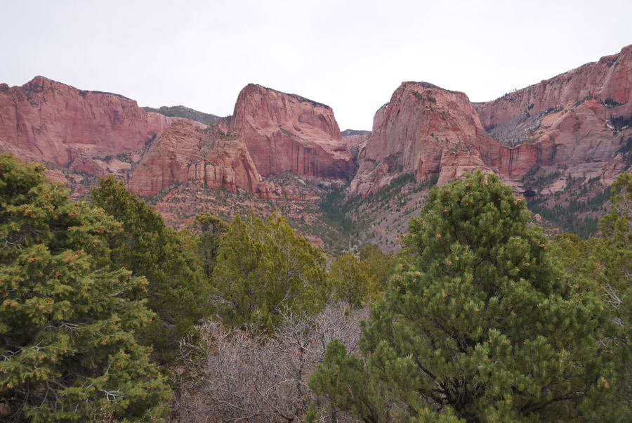
Kolob Canyons Road is a scenic drive that offers a glimpse into the finger canyons. The road ends high up on a ridge, at Kolob Canyons Viewpoint.
THE ZION-MOUNT CARMEL ROAD
The Zion-Mount Carmel Highway is the main DIY scenic drive in Zion National Park. The road begins near Springdale and climbs up a canyon wall in a series of switchbacks. Two tunnels—lit by windows that cut through to the cliff face—slice through the deep sandstone escarpment.
While primarily a thoroughfare with scenic vistas, the Zion-Mount Carmel Road is also home to one of the national park’s most scenic hiking trails.
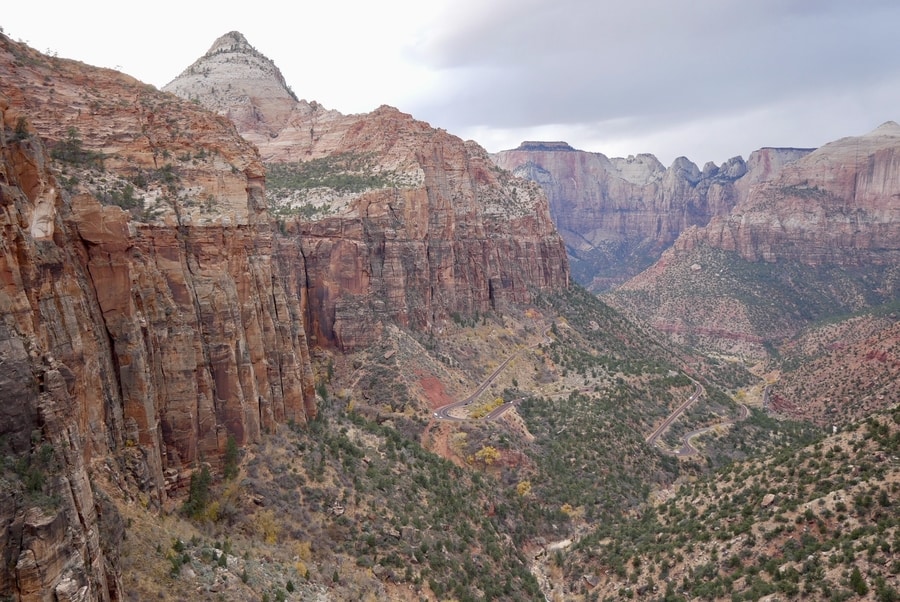
The one mile Canyon Overlook Hike is a must-do activity along the Zion-Mount Carmel Highway. Its sweeping vistas rival some of the most beloved viewpoints along the main Zion Canyon.
PRACTICAL TIPS FOR VISITING ZION
Zion is Utah’s most popular national park. It is a mecca for those seeking unparalleled desert scenery and iconic hiking trails.
Unfortunately, overwhelming crowds have forced Zion to enact a ban on private vehicles in the main canyon from July-November.
A shuttle service operates along the main canyon road during peak season. Be prepared for long lines and time-consuming waits.
-
ZION CANYON ENTRANCE FEE
Zion costs $35 to enter, per vehicle. The entrance fee is valid for both Kolob Canyons and the main area of the park. If you’re planning on spending more than seven consecutive days in the park, Zion annual passes cost $70, while Interagency Passes will set you back $80.
-
HOTELS NEAR ZION NATIONAL PARK
The historic Zion Lodge lies near the Emerald Pools Trailhead, about halfway down Zion Canyon. It is the best place to stay for those who want unparalleled access to the park’s trails and attractions.
Outside the park, most Zion tourists choose to stay in Springdale. Top-rated accommodations in Springdale include Flanigan’s Inn and the Red Rock Inn Cottages.
-
CAMPING IN ZION
Zion National Park is home to two established campgrounds. The South Campground and Watchman Campground (each $20), have more than 300 combined camping spots. They lie on either side of the visitor center, near the main entrance. Advanced booking is necessary.
BEYOND THE MIGHTY 5
The Mighty 5 are the undisputed highlights of Utah.
But for those who wish to add more flavor to their road trips, the state contains a number of places that are equally compelling.
-
GRAND STAIRCASE ESCALANTE
The Grand Staircase Escalante covers large swaths of southern Utah. It boasts awe-inspiring red rock landscapes and a litany of off-the-beaten-path attractions.
We’ve taken two trips through the Grand Staircase and have barely scratched the surface. In addition to the views from Highway 12, we particularly enjoyed traveling the Burr Trail Road and visiting Grosvenor Arch.
-
STATE PARKS IN UTAH
There are 43 state parks in Utah. Many of them lie in the southern third of the state and showcase red rock grandeur worthy of national park status. Some of the most beautiful state parks include Kodachrome Basin, Dead Horse Point, and Snow Canyon.
-
NORTHERN ARIZONA
Southern Utah and Northern Arizona have a lot of commonalities. They share an awe-inspiring red rock desert landscape that is second to none.
If you’ve got time in your itinerary, it is worth dropping below the border to visit Sedona, the Grand Canyon, and Upper and Lower Antelope canyons.
*****
While abroad, I often get asked advice on traveling to the USA. People want to know what places I, as a native, might recommend.
And southern Utah is almost unequivocally my first recommendation.
Sure, there are other extraordinary landscapes in my home country. Hawaii is paradisiacal. Alaska is wild. California is varied. Wyoming has Yellowstone. Montana has Glacier. Oregon and Washington have some of my favorite places on Earth.
But while I could spend all day singing praises about my beloved Pacific Northwest, Utah always springs to the top of my mind when discussing top USA travel destinations.
The state’s red rock desertscapes are extraordinary. Its Mighty 5 are unparalleled.
In my travels to over 100 countries, I’m not sure I’ve ever seen anything quite like them.
____________________________________________
Did You Enjoy this Guide to Utah’s Mighty 5? Pin It!