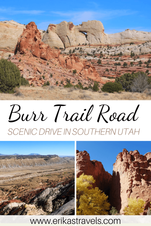
Driving the Burr Trail Road in Utah
Southern Utah’s desolate swath of desert features towering rock spires, chiseled canyons, and lonely dirt roads. It is a place that beckons to explorers and adventure-seekers. A place synonymous with the American West. A place where signs of life abound, despite the odds.
John Burr was a 19th century Mormon settler who grew up in this rugged and formidable backcountry. In order to move his cattle to greener pastures, he created a pathway that cut through the area’s barren desert and Waterpocket Fold.
The cattle trail later became known as the Burr Trail.
And today, the spectacular route is a scenic backway that showcases the majesty of Utah’s red rock country.
SOUTHERN UTAH’S BURR TRAIL ROAD
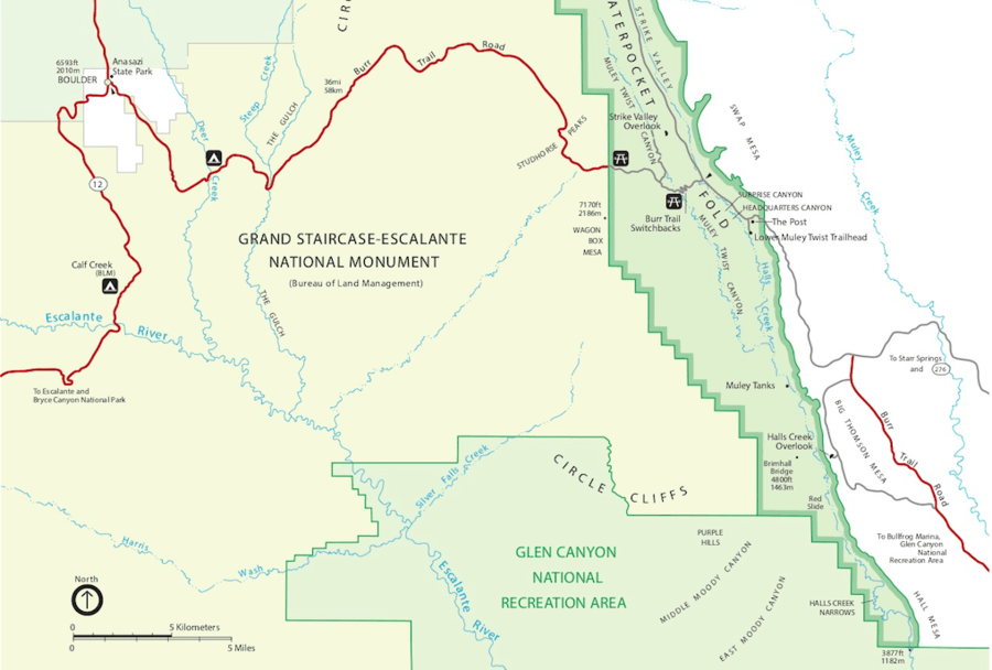
The Burr Trail Road is a lightly-traveled backway that winds through dramatic portions of southern Utah. The road extends for 66 miles, from the town of Boulder, to the Bullfrog Marina on Lake Powell. Along the way, it passes through Grand Staircase-Escalante National Monument, Capitol Reef National Park, and the Glen Canyon National Recreation Area.
The Burr Trail Road boasts a remarkable number of breathtaking attractions—including slot canyons, scenic viewpoints, and lonely offshoot roads that traverse juniper-laden desert.
Dan and I stumbled across the Burr Trail by accident. After exploring the lower reaches of Capitol Reef’s Waterpocket Fold, we found ourselves racing the clock in order to catch a flight back to Seattle.
Google Maps suggested we follow the Burr Trail Road to Boulder, instead of backtracking along the Strike Valley. Eager to witness parts of Grand Staircase-Escalante, we heeded its advice.
And in doing so, we had the opportunity to soak in some of southern Utah’s most spellbinding desertscapes.
BURR TRAIL ROUTE MAP
Most travelers begin their Burr Trail road trips in Boulder. The town of Boulder is a small outpost that lies within Anasazi State Park, along Utah’s Highway 12. It contains a gas station, a few dining options, and the route’s only hotels.
From Boulder, the road continues eastward through three areas that—while connected—are largely independent from one another.
The first section of the Burr Trail Road is a paved route that traverses the northeastern corner of Grand Staircase-Escalante National Monument. The second, is a rough-and-tumble gravel road that cuts across the Waterpocket Fold in Capitol Reef National Park. The third, is a ribbon of pavement then connects the national park’s Waterpocket District with the Bullfrog Marina on Lake Powell.
Though Dan and I began our exploration of the Burr Trail in Capitol Reef, this post documents the area’s attractions from west to east.
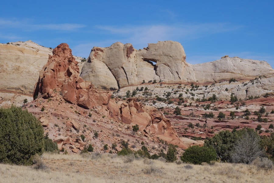
BURR TRAIL IN GRAND STAIRCASE-ESCALANTE NATIONAL MONUMENT
The Grand Staircase-Escalante National Monument spans nearly one million acres of America’s public lands. It is a diverse geologic treasure speckled with monoliths, slot canyons, natural bridges, and painted dune-like hills. Due to its remote location and rugged landscape, the monument was one of the last charted places in the continental United States.
On our drive along the Burr Trail, Dan and I had the opportunity to travel across a small portion of Grand Staircase-Escalante. Though our drive only afforded us a sampling of the monument’s vast riches, it allowed us to experience a slice of its colorful desert magic.
-
LONG CANYON
The Long Canyon is a scenic stretch of the Burr Trail that features spectacular red rock scenery speckled with dark green juniper trees. In the fall, splashes of yellow accentuate its Sedona-like shades of orange and green.
For seven miles, red sandstone cliffs rise steeply on either side of the road. Hidden within these towering walls are narrow slot canyons suitable for hiking detours.
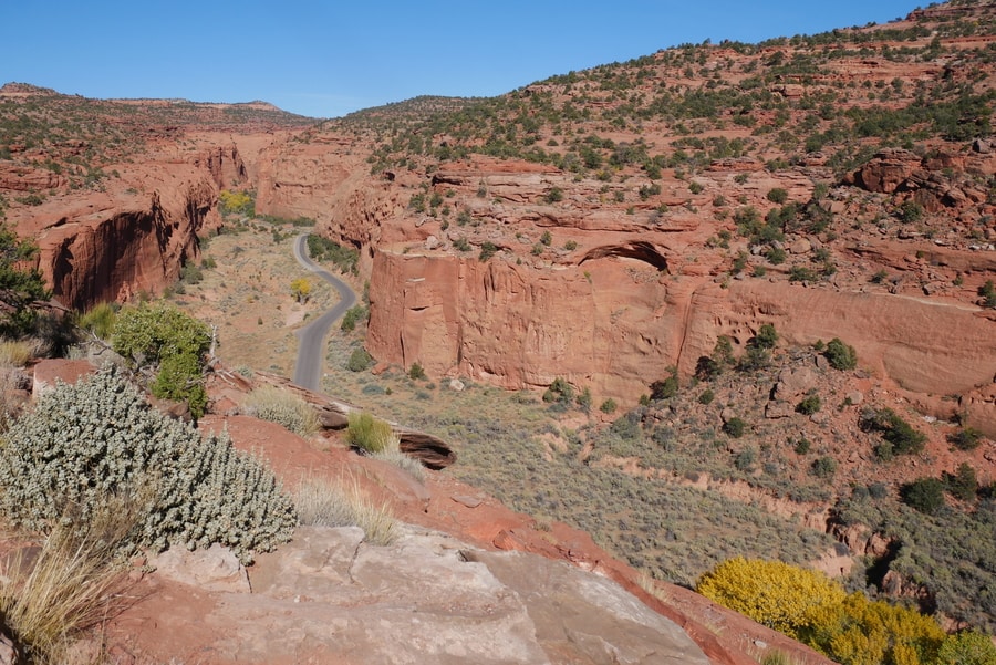
While we stopped frequently for photos, Dan and I didn’t have time to explore the area on foot.
However, had we done our research properly before visiting, we would have planned for a short 0.3 mile hike through Singing Canyon.
-
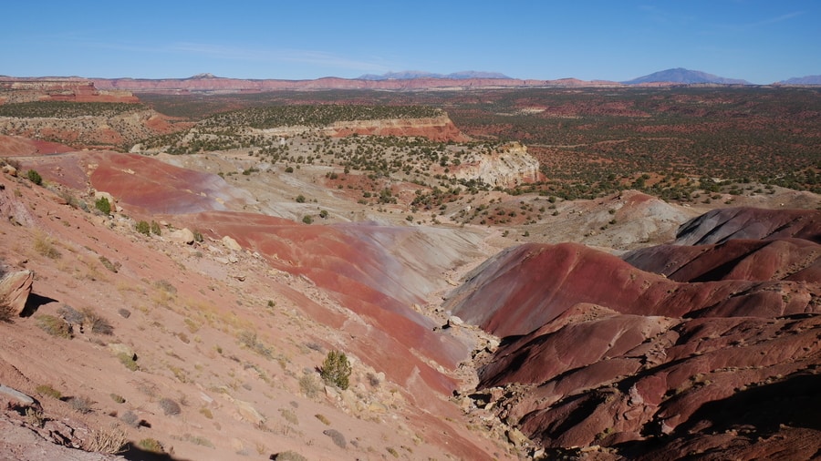
THE CIRCLE CLIFFS
Past Long Canyon, the Burr Trail Road enters a stretch of desert that is characterized by sweeping vistas and rich red earth. The geologically unique area boasts red and white rock mesas known as the ‘Circle Cliffs.’ An unmarked viewpoint along the Burr Trail Road provides exemplary panoramas over the area’s Circle Cliffs and Chinle Hills.
The Chinle Hills are dune-like landforms that burst with shades of pink, purple, and burgundy. They lie east of Long Canyon, among the Circle Cliffs. Like the Bentonite Hills along Capitol Reef’s Cathedral Valley Loop, they showcase the area’s intensely colorful terrain.
The Wolverine Loop Road, too, lies east of Long Canyon. It is a largely gravel loop that detours from the paved Burr Trail Road.
Dan and I didn’t have the opportunity to travel the Wolverine Loop. From our understanding, however, the road requires a high clearance 4×4 vehicle. It is also a popular route among mountain bikers.
BURR TRAIL ROAD IN CAPITOL REEF
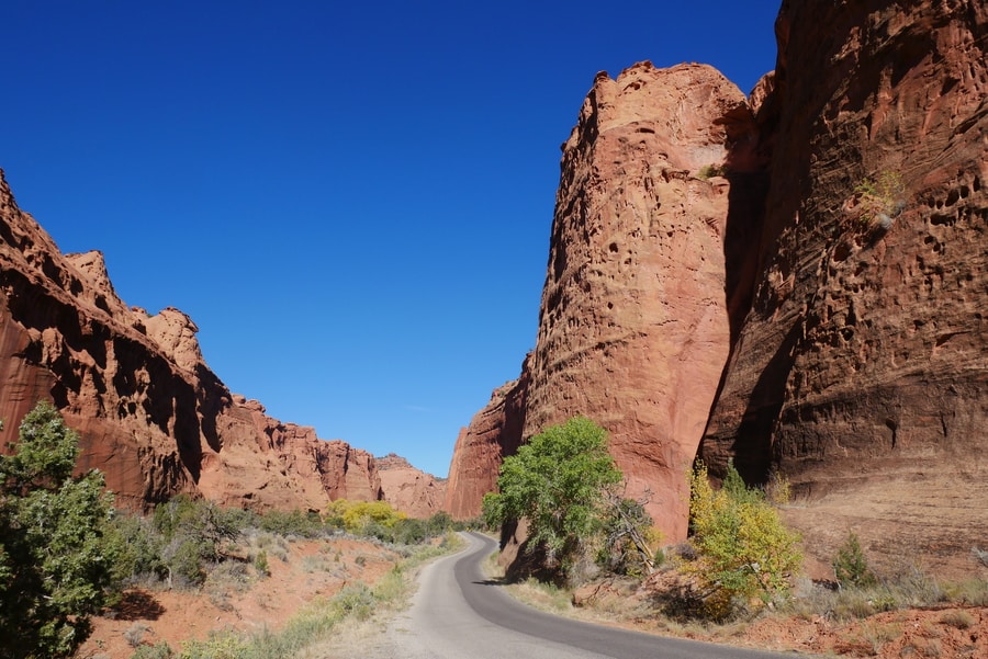
When the Burr Trail reaches the confines of Capitol Reef National Park, its ribbon of pavement switches to gravel and leads into the heart of the Waterpocket Fold.
The 100 mile-long Waterpocket Fold is a buckle in the earth’s surface. It is one of the most fascinating formations in Utah’s Mighty 5. The fold runs north-south, from Thousand Lake Mountain to Lake Powell. Along the entire length of the fold, erosion has cut through stratified rock layers—creating a fascinating host of narrow canyons and curious landforms.
The Waterpocket Fold is the main reason that Capitol Reef became a national park in 1971. The geological feature is a natural buffer that once blocked the westward migration of pioneers in the 1800s. It is said that the formidable wall proved to be a daunting obstacle in the path of explorers (much like an ocean reef blocking a ship’s passage).
Today, the Burr Trail is the only road that cuts across the daunting landform. Along its course, it provides spectacular aerial views of the 100-mile buckle.
-
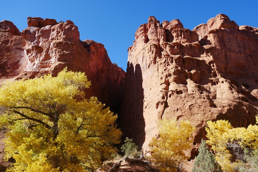
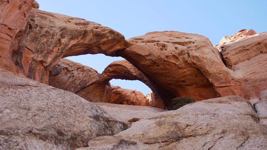
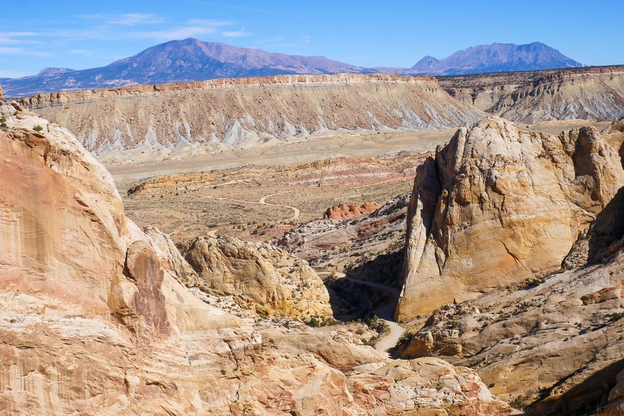
UPPER MULEY TWIST CANYON
To reach the Strike Valley Overlook, Dan and I followed a poorly maintained offshoot along the Upper Muley Twist Canyon.
We found the unpaved spur road to be treacherous and sometimes downright technical. Boulders and potholes littered the gravel track and nearly forced us to turn back on numerous occasions. We were so grateful to have rented a 4X4 vehicle with high clearance and good off-roading capabilities.
When we weren’t laser-focused on negotiating the road’s obstacles, Dan and I enjoyed some of the most beautiful views in Capitol Reef.
The three mile road is full of unmarked hidden gems and surprises. Along the short drive, we came across sheer cliffs, groves of yellow-clad cottonwood trees, and a beautiful double arch.
Two hiking trails leave from where the dirt road ends. One follows the 9 mile loop through the Upper Muley Twist Canyon. The other scales a shallow rock slab and leads to incredible views over the Strike Valley.
-
STRIKE VALLEY OVERLOOK
At the Strike Valley Overlook, the eastern profile of the Waterpocket Fold is on full display. The viewpoint provides the park’s best aerial panoramas and reveals a spectrum of rainbow colors—making it one of the most impressive destinations along the Burr Trail Road.
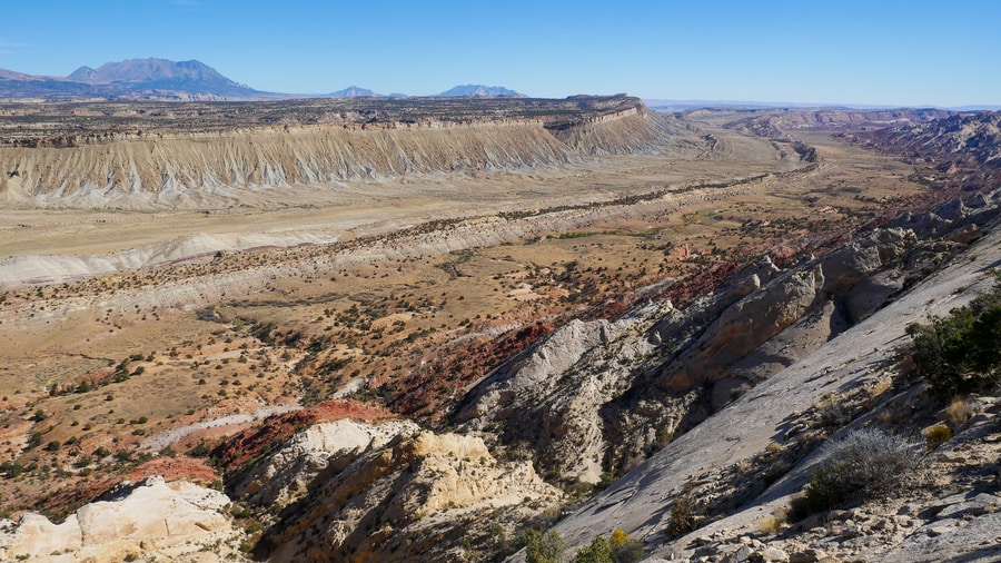
Visiting the Strike Valley Overlook is one of the top things to do in Capitol Reef. Ironically, it is also one of the park’s least visited areas.
Due to lack of services and poor roads, the Strike Valley Overlook is a place where one can contemplate the Waterpocket Fold’s unique geology in solitude.
-
BURR TRAIL SWITCHBACKS
Beyond the Upper Muley Twist Canyon, the unpaved Burr Trail descends into the Strike Valley.
In a series of switchbacks, the hairpin road traverses a daunting 800 ft rock escarpment that once vexed early explorers. With each and every bend, it affords breathtaking views of golden monoliths, rainbow-colored rock strata, and purple-hued mountains.
As we drove along the well-maintained Burr Trail Switchbacks, we stopped frequently to admire views of the Strike Valley from above.
We couldn’t believe that we had the panoramic vistas entirely to ourselves.
BURR TRAIL IN GLEN CANYON NATIONAL RECREATION AREA
The Burr Trail Road ends at the Bullfrog Marina, along the shores of Lake Powell.
During our trip to southern Utah, Dan and I didn’t have the opportunity to travel along the easternmost section of the scenic backway.
On a future road trip, however, we’d love to complete the journey.
****
The Burr Trail Road is one of the most beautiful scenic drives in Utah. It is a place where the area’s signature red rock landscapes become more dramatic by the mile. A place that remains wild, undeveloped, and pristine. A place where unexpected adventures lie behind every bend.
Though pavement now covers part of the route, Dan and I still encountered crowd-free vistas, hidden treasures, and washed out roads that were almost impossible to navigate.
And in those places, it wasn’t difficult to imagine what it must have been like to travel across the Waterpocket Fold, back in the days of John Burr.
________________________________
Did You Enjoy this Guide to Southern Utah’s Burr Trail Road? Pin It!