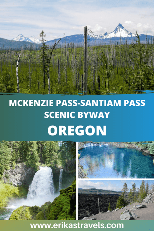
Driving Oregon’s McKenzie-Santiam Scenic Byway
In Oregon’s Cascade Mountains, two geologically fascinating ecosystems collide. On the west side of the Cascades, lush Douglas fir and red cedar forests conceal waterfalls and glimmering lakes. On the drier east side, ponderosa pines prevail and cloudless skies abound.
Oregon’s two halves clash in everything from climate to politics to scenery. The area of their convergence reveals a place that is at once hot and cold, wet and dry, living and dead. Charred forests give birth to new life. Frigid streams contain pockets of boiling water. Lava fields adjoin snow fields, providing visual reminders of the forces of fire and ice that have shaped the land.
When brought together, these contrasting elements create an outdoor-lover’s paradise of postcard-worthy backdrops and geologic wonder.
THE MCKENZIE PASS-SANTIAM PASS SCENIC BYWAY
The McKenzie-Santiam Scenic Byway is primarily made up of two roads: the narrow winding Old McKenzie Highway, and Oregon’s Route 126.
Both roads connect Sisters with the Willamette Valley. Both lead to some of Oregon’s most beautiful and underrated gems.
While they are often traveled independently of one another, the two roads combine to create an unforgettable route that showcases the diverse geology of Oregon’s central Cascades.
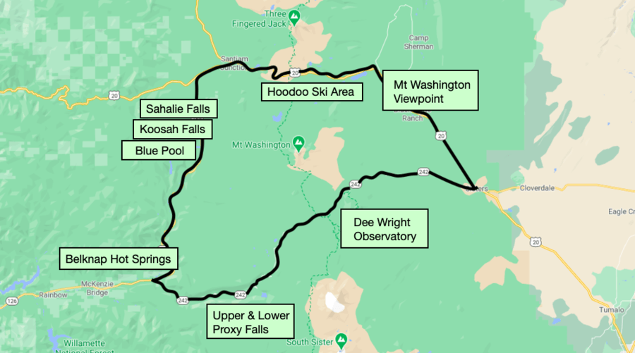
If approached from the east, the McKenzie Pass-Santiam Pass Loop begins and ends in the western-themed town of Sisters. Alternatively, you can start the loop near McKenzie Bridge.
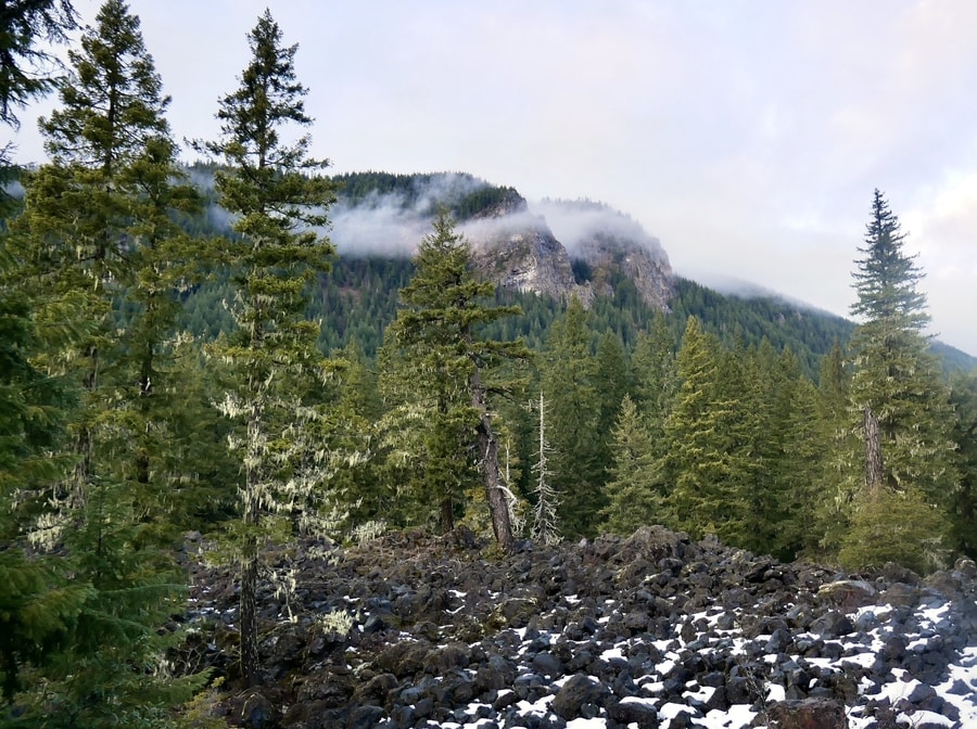
Along its course, the byway journeys through verdant forest and provides peek-a-boo views of snowcapped volcanoes.
Broken Top Mountain, Mount Washington and The Three Sisters tower above the area, while waterfalls and rivers lie hidden beneath its carpet of evergreen trees.
THE MCKENZIE RIVER HIGHWAY: OR-126
The OR126 contains no shortage of places to see. The highway crosses much of the state and connects the central Oregon coast with Sisters.
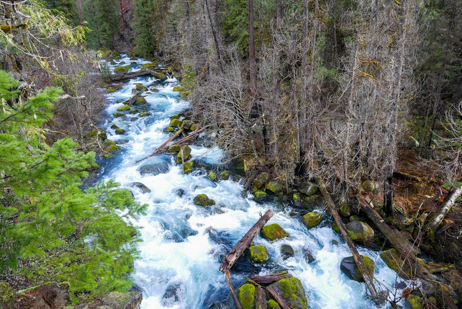
As it leaves the oceanside city of Florence, the ribbon of pavement traverses a shallow coastal mountain range and enters the fertile Willamette Valley. After passing the Eugene-Springfield metro area, it follows the McKenzie River through the Willamette National Forest—where it reveals plunging waterfalls, turquoise pools, and secluded hot springs.
Parts of Highway 126 suffered severe damage during the Holiday Farm Fire of 2020. East of Eugene, between Vida and McKenzie Bridge, the road passes through wildfire-scorched landscapes that reveal heartbreaking destruction.
If you’re intending to approach the McKenzie-Santiam Loop from the west, check updated information before planning a trip to the area. Debris and landslides still present significant hazards. And the scars from the devastating wildfire season are visible reminders of the area’s long path toward recovery.
BELKNAP AND COUGAR HOT SPRINGS
Central Oregon’s abundant volcanic activity has resulted in a smattering of thermal springs. The McKenzie Highway is home to two of the most beloved hot springs in Oregon: Belknap and Cougar (also known as Terwilliger).
Belknap is a developed mini-resort with hotel rooms and a concrete pool. For non-guests, soaking costs $8 per hour and is permitted between 9am and 6pm on weekdays.
Nearby Cougar consists of clothing-optional pools that cascade down the river like a necklace chain. A natural spring, it contains six soaking areas that are spaced apart by rock walls and surrounded by verdant forest. They range in temperature from 85 to 112 degrees.
Due to wildfire damage in 2020, the Cougar Hot Springs are temporarily off-limits.
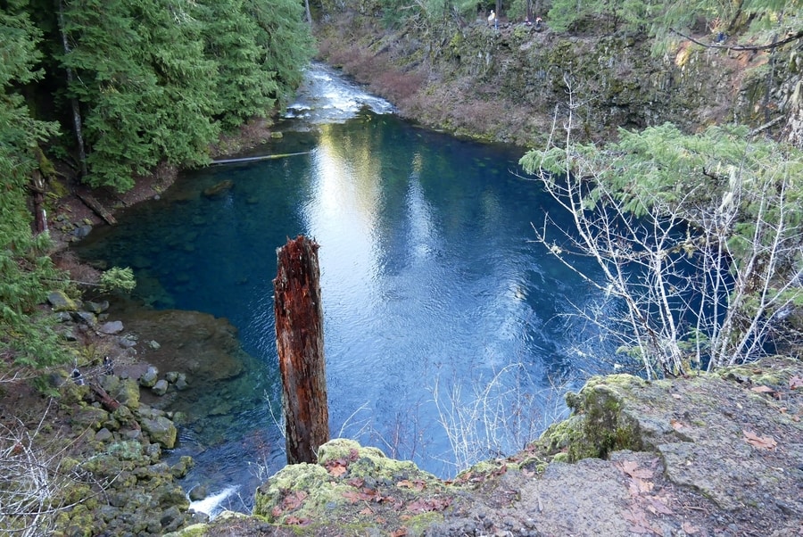
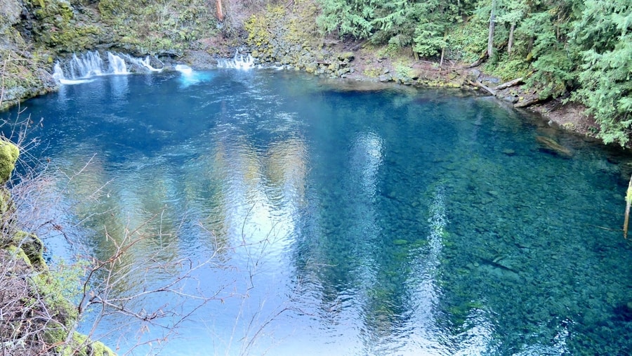
THE TAMOLITCH POOL
The Tamolitch Pool lies along the ambling McKenzie River Trail. Known alternatively as the ‘Blue Pool’ for its striking color, it is one of the most beautiful bodies of water in Oregon.
Some 16,000 years ago, lava flow from Belknap Crater buried a 3 mile stretch of the McKenzie River. Thus, while the Blue Pool seems to spring out of nowhere, it is actually the continuation of a river that momentarily sinks below ground. When the river resurfaces, it seeps through porous lava, creating a pristine turquoise swimming hole. The porous rock acts as a natural filter, removing contaminants and resulting in a shade of blue that is almost difficult to believe.
The Tamolich Pool’s jewel-like water alternates between shades of turquoise, sapphire and emerald. When light touches its surface, the blue pool is almost iridescent.
The 3.7 mile out-and-back trail to the Blue Pool is a popular day trip from both Eugene and Bend. Its popularity has risen dramatically in recent years.
When I was growing up, I’d never even heard of the Blue Pool.
Now, its photos are plastered all over social media and its scintillating waters draw tourists from all corners of the state and beyond.
SAHALIE AND KOOSAH FALLS LOOP
The Sahalie and Koosah Falls Loop is one of the most popular hikes along Oregon’s McKenzie River. Reminiscent in some ways to the lauded Trail of Ten Falls near Salem, it is a multi-cascade trek that boasts unforgettable waterfalls and a lush forested setting.
The two waterfalls lie along a 26 mile river trail that also includes the Tamolitch Pool. Portions of the river trail are popular among hikers and mountain bikers.
Most visitors, however, choose to explore the two cascades as part of a 2.6 mile loop from the Sahalie Falls parking lot.
-
SAHALIE FALLS
Sahalie Falls is a raging cataract that pounds the river into rainbow prisms. Its impressive rush of white water pours 100 ft over a naturally-formed lava dam.
All around, mossy vegetation carpets the area in shades of emerald.
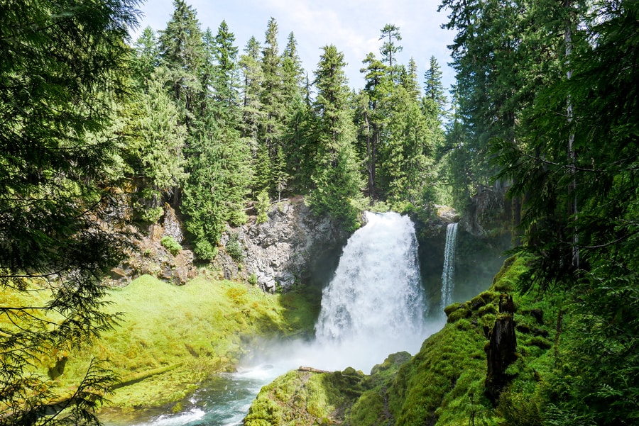
At times of high water, a secondary stream drops into the lava bowl to the right of the main cascade—adding character to an already picturesque scene.
-
KOOSAH FALLS
Though slightly smaller and less popular than its neighbor, Koosah Falls is no less impressive. The cascade pummels over lava rock and empties forcefully into the sapphire waters of the McKenzie River.
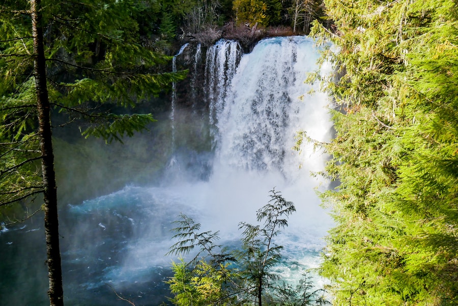
While 64 ft Koosah Falls contains its own parking area and is easily accessible from the highway, most choose to visit the attraction as part of the Sahalie Falls Loop.
HOODOO SKI AREA
Hoodoo is a local ski resort that caters to families from the Willamette Valley and Central Oregon. It is home to five lifts that provide access to 800 acres of skiable terrain.
During winter months, it becomes one of the top outdoor playgrounds in the Oregon Cascades.
MOUNT WASHINGTON VIEWPOINT
After crossing over Santiam Pass, the landscape along Oregon’s Highway 126 transforms. The Ponderosa-clad Deschutes National Forest replaces the moss-covered fir trees of Oregon’s western half. On either side of the road, snow-capped mountains peek out over the fire-charred forest.
Between Hoodoo and Sisters, roadside pullouts offer views of steep-sided Mount Washington and the iconic Three Sisters.
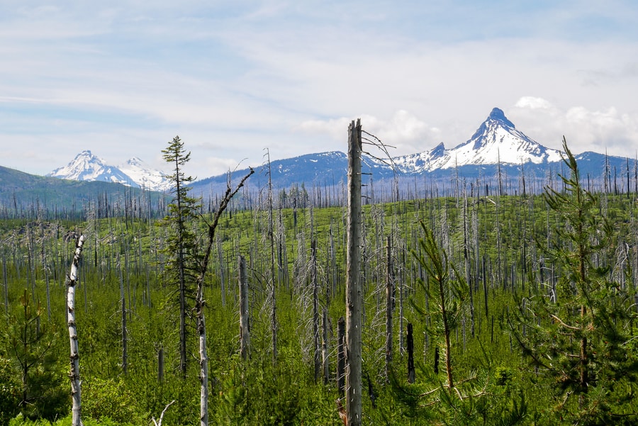
Mount Washington rises above lava-strewn plains. Though it is one of the most impressive attractions in Oregon’s Cascades, the craggy peak is often overlooked.
The McKenzie-Santiam Highway provides some of the state’s best views of the sheer mountain and its surroundings.
OLD MCKENZIE PASS SCENIC BYWAY: OR-242
The Old McKenzie Highway is one of Oregon’s most scenic drives. The seasonal highway (accessible from July through September) cuts between two of Central Oregon’s top wilderness areas and connects the towns of Sisters and McKenzie Bridge.
Along the way, it provides access to countless historic, recreational, and scenic attractions—including lunar landscapes, waterfalls, and old growth forests.
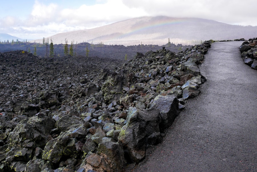
The Old McKenzie Highway follows the path of an 1860s wagon route. It highlights jaw-dropping vistas of Mount Washington and a 65-square-mile lava flow.
Beyond the sprawling lava flow, it snakes through emerald forest and passes by stunning waterfalls.
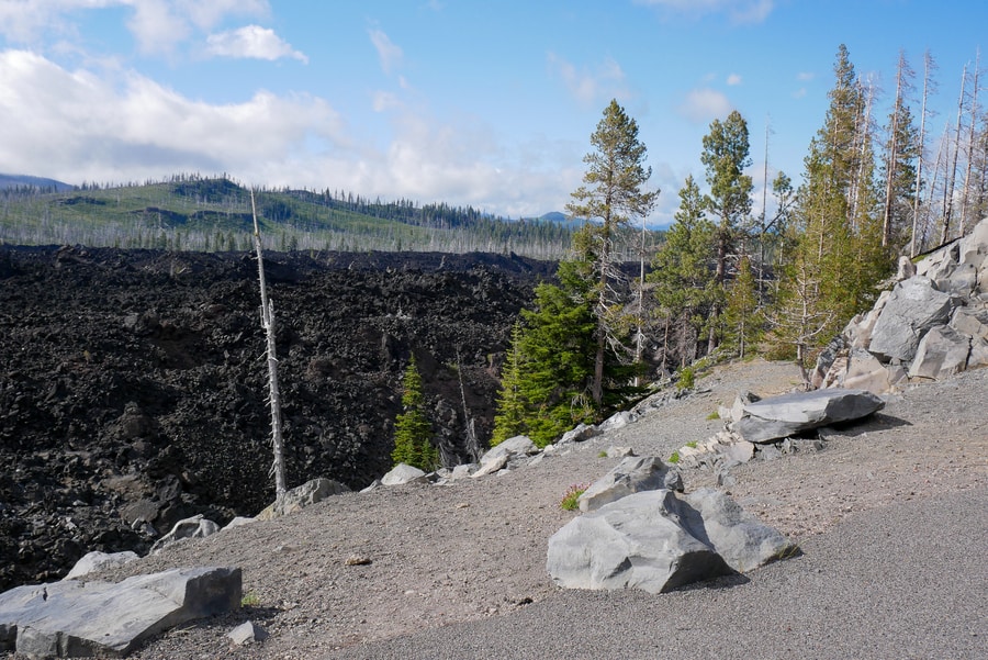
DEE WRIGHT OBSERVATORY
The Dee Wright Observatory is located in the Oregon Cascades, atop a barren blanket of lava in the Willamette National Forest. It overlooks a 65-square-mile sea of black lava rock.
The Dee Wright Observatory dates back to the 1930s, when the Civilian Conservation Corps constructed the structure to showcase the area’s spectacular topography. The rocky shelter features a number of viewing windows, some of which have been specifically aligned to capture views of prominent peaks.
As with the nearby Newberry Crater National Monument, the volcanic lunar landscape near the Dee Wright Observatory caught the attention of NASA astronauts planning a mission to the moon. Scientists believed that the moon’s mysterious pockmarked surface was a result of volcanic activity.
So in order to prepare for what they might encounter in space, they performed extensive fieldwork and equipment testing in the area.
It isn’t difficult to see why the Oregon lava lands represented their closest approximation to the moon’s surface.
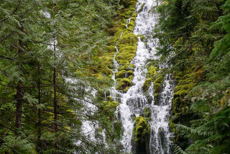
PROXY FALLS
The Proxy Falls Trail passes through lava fields that have been reclaimed by forest. It features two lovely waterfalls that spill over mosses and ferns.
Though the Old McKenzie Highway remains closed to vehicle traffic for much of the year, Proxy Falls is accessible year-round. When Dan and I visited in winter, we parked at the snow gate on the road’s western end.
From the gate, we hiked up the highway for two miles, before veering off toward the waterfall.
I’ve read that the Proxy Falls trail can get crowded in summer.
During our winter visit, however, we found ourselves standing before the 254 ft waterfall in complete solitude.
-
UPPER PROXY FALLS
At 129 ft, Upper Proxy Falls is the smaller of two beautiful waterfalls that lie along the Old McKenzie Highway. Its vertical stream trickles over a carpet of dense green moss and ferns.
Though the cascade itself is beautiful, its most particular characteristic is the fact that its water seems to vanish upon reaching the ground.
Instead of flowing onward, the waterfall’s ribbon of water plunges into porous subsoil and sinks below lava rock.
-
PROXY FALLS
Proxy Falls pours 226 ft into a gaping canyon in the Willamette National Forest.
The cascade’s wispy tentacles spread out over the rock like a dense spider web. I found it quite reminiscent to Spray Falls in Washington’s Mount Rainier National Park.
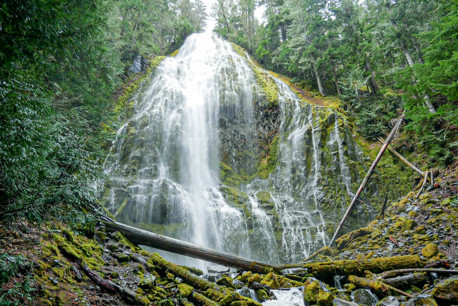
With its graceful form, mossy surroundings, and fairy tale aesthetic, Proxy Falls is one of the most beautiful cascades in the Pacific Northwest.
Having the attraction completely to ourselves made our experience all the more magical.
WHERE TO STAY ALONG THE MCKENZIE-SANTIAM HIGHWAY
Sisters is a picturesque western town that acts as the gateway to some of Central Oregon’s best recreation. It boasts wonderful places to stay—including the FivePine Lodge, the Best Western Ponderosa Lodge, and the GrandStay Hotel and Suites.
Outside of Sisters, accommodation is mostly relegated to camping. There are numerous primitive and established campsites scattered along the loop.
WHEN TO VISIT THE MCKENZIE-SANTIAM HIGHWAY
Driving the full McKenzie Pass-Santiam Pass Loop is only possible between July and September, when warm sunny temperatures dominate the weather forecast. Much like the Cascade Lakes Highway, the OR-242 remains closed to vehicle traffic during Oregon’s snowy season.
That being said, many of the area’s attractions are still accessible year-round. Highway 126 is fantastic in winter, when the waterfalls plunge in full force and crowds are few and far between.
If you’re willing to put in a little extra effort, Proxy Falls makes for a fantastic (albeit longer than normal) winter day hike.
And after a day of exploring Oregon’s waterfalls in the cold and rain, the area’s thermal hot springs are all the more rewarding.
****
Oregon’s highest mountains create wildly contrasting landscapes. Along the McKenzie Highway’s scenic loop, the juxtaposition of fire and ice reveals a land that has been carved by the elements and sculpted by forces of nature. Glaciated peaks rise up from stark black lava fields. Charred trees—once ravaged by wildfires—give birth to fledgling vegetation. Ice-cold waterways lie adjacent to steamy thermal pools.
And amidst its wildly contrasting landscapes, the drive showcases nature’s capacity for beauty, as well as its wanton tendency toward destruction.
__________________________________________
Did You Enjoy this Guide to the McKenzie Pass-Santiam Pass Scenic Loop in Oregon? Pin It!