Visiting Mount Rainier National Park
Mount Rainier is the contiguous USA’s fifth-tallest mountain and the highest peak in the spectacular Cascade Range. Depicted on every Washington license plate, eponymous to everything from beer brands to cherries, and visible throughout much of the state’s western half, it is a towering landmark that has become one of the Pacific Northwest‘s most recognizable and beloved symbols.
The sky-scraping mountain is a constant visible reminder of the region’s remarkable geology. Within its confines, Mount Rainier National Park hosts an ecosystem that is studded with geologic wonders and natural splendor. The park boasts wildflower-strewn meadows, waterfalls gushing down glaciated valleys, and mile upon mile of forested trails.
Washington’s tallest mountain may be visible from hundreds of miles away but, up close, it is a magical wonderland that invites hikers, photographers, and lovers of fresh mountain air.
MOUNT RAINIER NATIONAL PARK
Mount Rainier National Park is one of three federally protected national parks in Washington State (the other two are Olympic National Park and the North Cascades). The park lies in the snow-draped Cascade Mountains, between Portland and Seattle. Its main feature is an active volcano that last erupted in 1894. It is the most glaciated peak in the contiguous United States, and certainly one of its most iconic.
The area’s Native Americans called the mountain Tahoma, meaning the ‘mother of waters.’ Somewhat lamely, however, George Vancouver later officially named the mountain after his friend, Admiral Peter Rainier. The British admiral had never even seen the mountain in person.
For over a century, various movements have sought to return the mountain to its original name.
Most Washingtonians, however, simply refer to it as ‘the Mountain.’
Entering Mount Rainier costs $35 per vehicle, or $55 for an annual pass. Interagency passes are also accepted and can be obtained online or at the park’s entrance kiosks.
Mount Rainier National Park has four main entrances—Carbon River in the northwest, Stevens Canyon in the southeast, White River in the northeast, and the ever-popular Nisqually entrance in the park’s southwest corner.
PARADISE VALLEY: NISQUALLY ENTRANCE
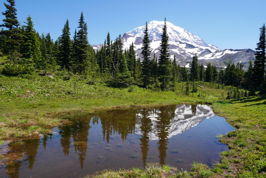
If you’re planning your first visit to Mt Rainier, chances are you’ll choose to visit Paradise. Home to the historic Paradise Inn, and the starting point for many breathtaking day hikes, the Paradise section of the national park is arguably Washington State’s most scenic destination.
The wildflower-clad meadows at Paradise remain the park’s most irresistible draw. They are home to gushing waterfalls, stellar views, and a large assortment of animals. On sunny days—when Rainier decides to take off its cloudy shawl—the mountain views from Paradise are simply breathtaking.
SKYLINE TRAIL IN PARADISE
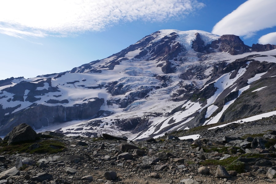
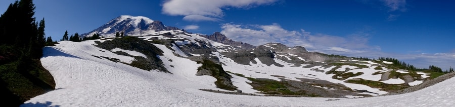
If you only have time for one trail in Mount Rainier National Park, then the 5.9 mile Skyline Trail loop should be a top contender. The trail is one of the most popular in the park. And for good reason. It traverses bubbling streams, wildflower-laced meadows, and alpine forest.
On clear days, it boasts panoramic views of Mount Rainier’s bulbous summit.
The Skyline trail begins as a wheelchair accessible paved walkway for the first mile or so. Shortly after Myrtle Falls, it turns into a rocky hiking path.
When we hiked the Skyline Trail in July, snow still obstructed much of our path. We were nonetheless able to traverse the snowed-in sections, but found that our success was largely thanks to the fact that we brought hiking poles.
-
MYRTLE FALLS
Idyllic Myrtle falls sits in the Paradise Valley, about 0.5 miles from the start of Mount Rainier National Park’s Skyline Trail. It is a great short hike for those visiting Mt Rainier with family.
Though Myrtle Falls isn’t the biggest or most dramatic waterfall in Washington, its setting below the towering snow-capped peak of Mount Rainier is certainly among its most majestic.
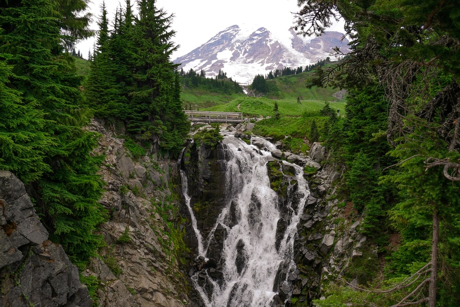
Before the Skyline Trail crosses Edith Creek, a short dirt track veers off the main pathway to the base of Myrtle Falls. The path brings hikers to a crowded viewpoint that perfectly frames Myrtle Falls as it tumbles below Mount Rainier’s snow-covered summit.
-
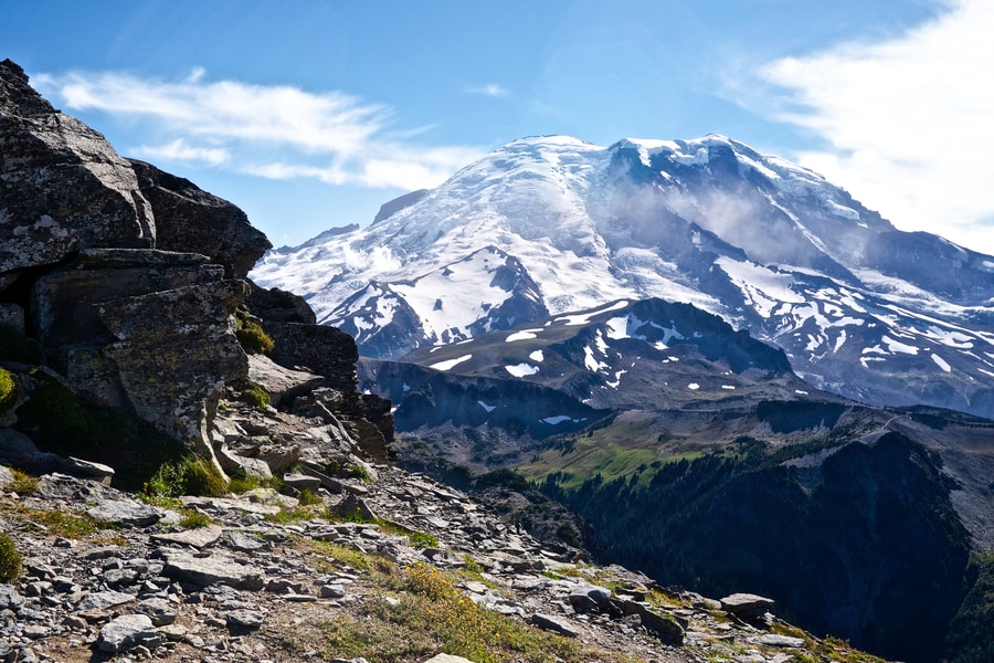
PANORAMA POINT
Panorama Point is the last of many rewards along the Skyline Trail. The observation point boasts incredible 360 degree views of the surrounding mountain-clad landscape. To the north, close-up views of Mount rainier’s snow-covered summit are some of the best in the park. To the south, the Tatoosh Buttes jut upwards like the ridges on a dragon’s back.
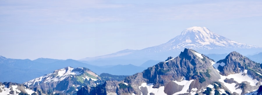
Past the buttes, Mount Adams reflects an almost perfect mirror image of Rainier. And beyond, Mount St Helens, and Mount Hood peek out above rolling verdant hills.
NARADA FALLS
Narada Falls is among the most popular places to visit in Mount Rainier National Park. The gushing 176 ft waterfall is one of the prettiest in Washington State.
The popular Mt. Rainier waterfall is located on the road from Longmire to Paradise. A small trail departs from the parking area and leads visitors to a viewing area that showcases head-on views of the cascade.
SUNRISE AREA: WHITE RIVER ENTRANCE
At an elevation of 6,400 feet, Sunrise is Mount Rainier National Park highest vehicle-accessible point. Though it is only open for four months out of the year due to snow, it sits in the mountain’s rain shadow and is considerably drier than other points in the park. As its name suggests, Sunrise is the first part of the park to capture morning’s early light. It is the park’s second most visited area and a popular day trip from Seattle.
On clear summer days, Sunrise provides breathtaking views of Mount Rainier, Emmons glacier, and vibrant wildflower meadows.
When we visited Sunrise, Dan and I chose to hike the popular trail to the Fremont Fire Lookout. As with our hike in Paradise, the area showcased spectacular panoramas of the mighty mountain and its surroundings.
FREMONT FIRE LOOKOUT HIKE
The 5.6 mile Fire Lookout Trail starts near the Sunrise Visitor Center and climbs to the top of Sourdough Ridge, until it reaches the placid waters of Frozen Lake.
From the lake, the path continues to a 1930s fire lookout tower via a spectacular rocky ridge.
Sunrise’s Fire Lookout Trail traverses meadowland and features postcard-worthy photo opportunities of Rainier and its surrounding rocky crags.
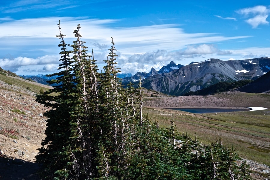
MOWITCH LAKE ENTRANCE NEAR THE CARBON RIVER
The Carbon River Ranger Station and Wilderness Information Center is Mount Rainier’s smallest and least visited park center. Ironically, it is the closet one to the Seattle-Tacoma metropolitan area. Located in the northwestern corner of the park, the ranger station invites visitors to explore a unique ecosystem within the park’s inland temperate rainforest.
Near the Carbon River entrance, a road travels up the mountainside, to Mowich Lake. The majority of the road is unpaved and can be quite rough.
As a result, it remains somewhat off the beaten path.
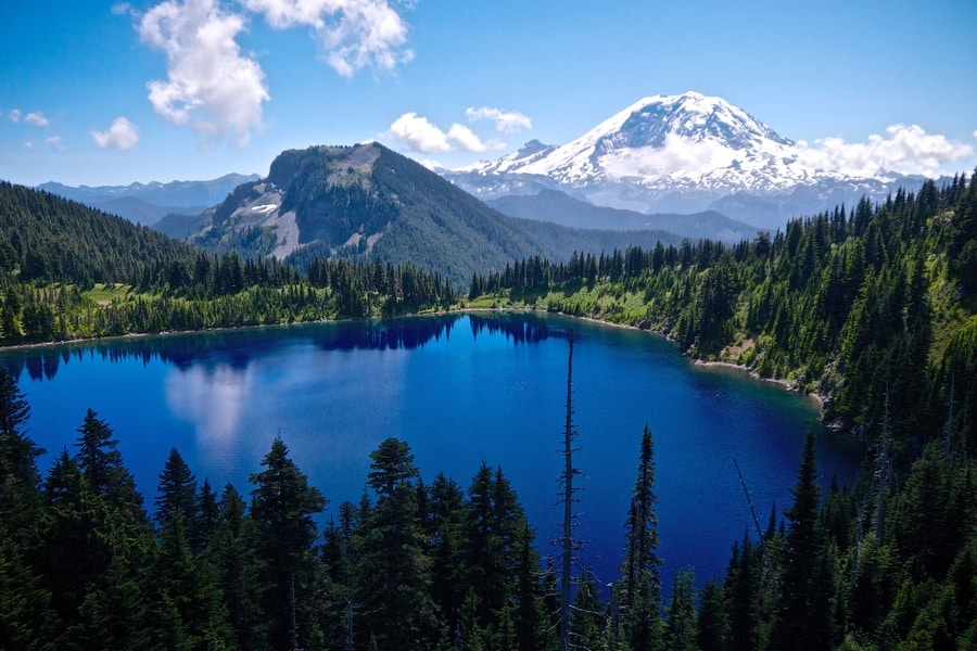
MOWICH LAKE
Mowich Lake is the largest and deepest lake in Mount Rainier National Park. Set in a glacial basin surrounded by fragile meadows, it is a popular place to enjoy a relaxing afternoon of fishing or kayaking. The area is generally open from mid-July to mid-October.
Its adjacent campsite is free and open to the public on a first-come, first-served basis.
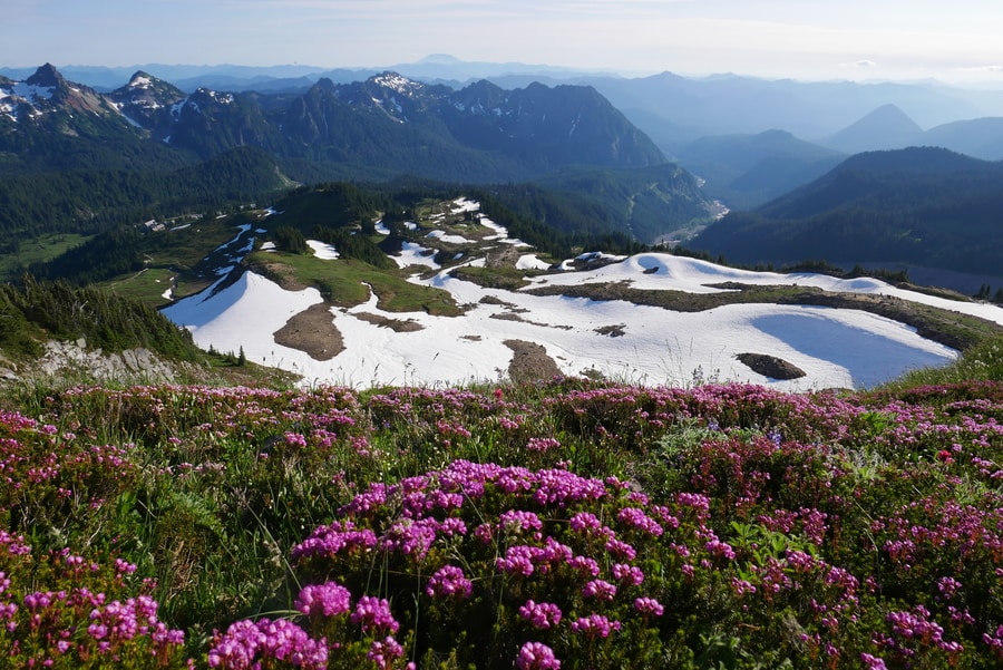
SPRAY PARK HIKE
Awash with an avalanche of colorful alpine flowers, Spray Park is one of the most scenic areas in Mount Rainier National Park. It offers wildflower-strewn meadows akin to those of Paradise, with only a fraction of the crowds.
The 8 mile roundtrip Spray Park hike begins at the Mowich Lake Campground, at the end of a 16-mile drive on a potholed gravel road. The trail features photogenic meadows and one of the park’s most beautiful waterfalls.
For the first half mile or so, the path follows the Wonderland Trail—a 93-mile route that encircles Mount Rainier. At about two miles in, the path forks. One route leads to Spray Falls, while the other continues to Spray Park.
-
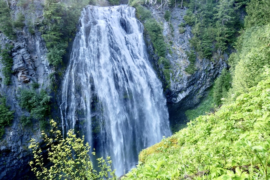
SPRAY FALLS
Dan and I decided to take the detour to Spray Falls, before continuing with our hike to the park’s flower-speckled meadows. Spray Falls is one of the tallest cascades in Mount Rainier National Park. The waterfall tumbles 354 feet over a sloping rock face and is one of the area’s most arresting water features. Living up to its name, the waterfall consists of wispy strands that trickle delicately over a wall of moss-covered andesite.
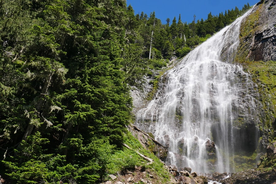
Whether or not you choose to hike all the way to the Spray Park Meadows, I recommend you take the time to visit Spray Falls. It is one of the most beautiful waterfalls in Washington State and a highlight of the national park’s northeastern section.
-
SPRAY PARK MEADOWS
After our detour, Dan and I rejoined the main trail and headed upward—along a series of switchbacks—to Spray Park. The park’s verdant valleys are dotted with specks of magenta, yellow, red, purple and white.
Beyond, the towering Tahoma forms a spectacular backdrop.
Due to large bodies of standing water, Dan and I found Spray Park to be full of mosquitoes when we visited in mid-July. In fact, the mosquitoes were so vicious, that I immediately understood why we saw many hikers wearing full face-covering nets.
STEVENS CANYON ENTRANCE
The Stevens Canyon entrance to Mount Rainier lies just east of Packwood, along the White Pass Scenic Byway. The seldom-visited entrance is the gateway to the Grove of the Patriarchs. It contains some of the park’s most beautiful old-growth forest and is home to the Ohanapecosh Visitor Center and Campground.
I have not yet visited the attractions near Mount Rainier’s southeastern corner, but hope to make the area a priority on my next trip to the national park.
VIEWS FROM OUTSIDE THE PARK
At more than 14,000 ft, Mount Rainier is visible from hundreds of miles away. From Seattle, peek-a-boo views make the monolithic mountain appear far closer than its actual location.
The mountain’s stately stature means that you don’t have to be within the park’s boundaries to enjoy views of its snowcapped summit.
SUMMIT LAKES TRAIL
The hike to Summit Lake offers some of Washington’s most spectacular views of Mount Rainier. Though it technically lies outside of the Mount Rainier National Park boundary, its striking scenery makes it a popular and worthwhile place to visit when traveling in the area.
The Summit Lakes Trail is a 6.1 mile roundtrip path that offers an incredible payoff. On clear days, the mountain soars above the lake’s cobalt waters, as a tapestry of emerald forest accentuates the foreground.
WHERE TO STAY NEAR MOUNT RAINIER
Mount Rainier National Park has three established campsites that are suitable for both tents and RVs. The campsites are located at Cougar Rock, Ohanapecosh, and White River. Each campsite charges $20 for a tent site and is best reserved months in advance.
For travelers who enjoy a little more comfort, a host of lodging options lie along the road, near the Paradise entrance. Most of the places to stay offer chalet or cabin style lodging. Accommodations with fantastic reviews include Alexander’s Lodge, the Cozy Studio Apartment, and the Little Red Cabin.
WHEN TO VISIT MOUNT RAINIER NATIONAL PARK
Mount Rainier is one of the most awe-inspiring places to visit in the United States. However, for much of the years, the national park becomes largely inaccessible. Due to Mount Rainier’s high altitude and snowy conditions, roads leading up to the park are often closed in winter and spring. During these months, trail access is severely limited.
Though outdoor-lovers can visit Mount Rainier in winter with a solid pair of snowshoes, I recommend visiting between June and early October.
In summer, when some of the roads and hiking trails begin to open for the season, the mountain showcases flower-carpeted meadows. Late summer is one of the most beautiful times to visit Mount Rainier, as the mountain is far more likely to show its face on sunny days.
By early autumn, when most of the snow around the base of the mountain has melted, the park is a wonderland for hikers and backpackers.
WILDLIFE IN MOUNT RAINIER
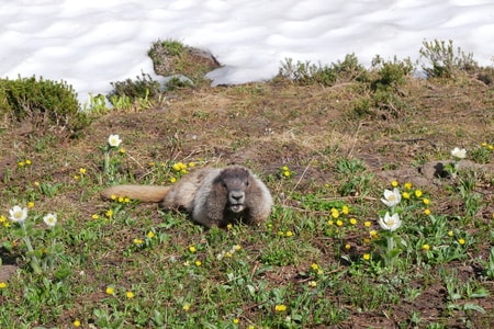
Mount Rainier’s meadows host a varied assortment of animals.
When the snow melts on the mountainside, chipmunks, pika and marmots scamper about the wildflower-clad meadows. At higher elevations, mountain goats trod along jagged ridges and rocky outcrops.
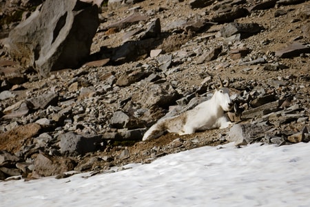
Following our unsuccessful search for mountain goats in Oregon’s epic Wallowas, we were eager to spot mountain goats at Rainier. And it didn’t take long before we saw one lounging on the mountainside, like a camouflaged patch of late-summer snow.
While encounters with wildlife can be unforgettable, please always remember to refrain from feeding the animals.
****
Mount Rainier is the crown jewel of Washington State. It is the Pacific Northwest’s most iconic peak, one of Washington’s most notable tourist attractions, and a symbol that is emblazoned on everything from license places to beer cans, to .25 cent coins.
Sure, the mountain gets a lot of hype.
But every ounce of its notoriety is completely and 100% deserved.
_______________________________________
Did You Enjoy this Guide to Mt Rainier National Park in Washington State? Pin It!