Off the Grid at Hells Canyon in Oregon
When explorers came across the immense canyon that forms the border of present-day Oregon and Idaho, they figured they may as well have stumbled upon Hell. The inhospitable landscape—home to rattlesnakes, sweltering temperatures, and rugged barren landscapes—proved to be a formidable obstacle on their westward journeys.
Many tried to tame the Snake River with boats and ferries, but hardly any were successful.
Even today, Hells Canyon is no easy place to visit. The cavernous river gorge is remote, desolate, and hundreds of miles from the trodden tourist trail.
But it is also a scenic gem that is as undiscovered as it is breathtaking, and as difficult to reach as it is worthwhile.
Unlike the world-renowned red-rock canyons of the American Southwest, Hells Canyon has very little name recognition.
Few people have heard of the vast wilderness area.
Even fewer have traveled to the middle of nowhere to see its grandeur with their own eyes.
HELLS CANYON NATIONAL RECREATION AREA
The Hells Canyon National Recreation Area consists of a system of river gorges in northeast Oregon and western Idaho. Though Hells Canyon admittedly doesn’t boast the same dramatic colors as Arizona’s Grand Canyon, its immensity is every bit as impressive. Hells Canyons’ scale can be deceiving. At its widest, it extends 10 miles. Its walls tally a whopping 7,913 ft —nearly 2,000 ft more than those of Arizona’s beloved geologic wonder—making it the deepest river gorge in North America.
Hells Canyon’s walls shelter a massive wilderness area that contains dispersed camping opportunities and miles of rarely-trodden trails. The far-flung outdoor playground encompasses more than 200,000 acres of wilderness managed by the U.S. Forest Service.
The remote nature of Hells Canyon makes it a time-consuming place to explore. The canyon’s incongruous roads are often disconnected and indirect. To get from one viewpoint to another can take the better part of a day.
For travelers with limited time, I recommend focusing on Hat Point Road and the Hells Canyon Scenic Byway.
THE IMNAHA ROAD TO HAT POINT OVERLOOK
For the most dramatic views of Hells Canyon from above, adventure-loving travelers can take the spectacular unpaved route to Hat Point Overlook.
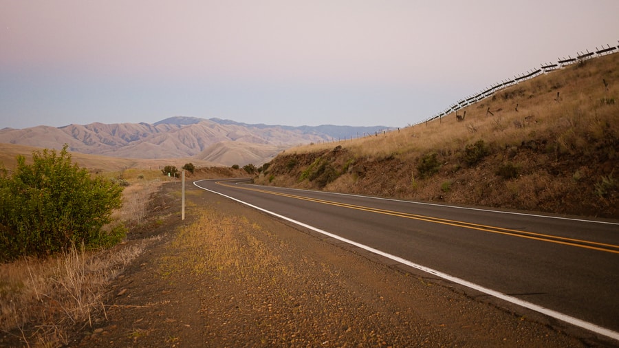
To reach Hat Point from Joseph, Dan and I followed Highway 350 for about 30 miles, to the tiny community of Imnaha. From there, we headed down a narrow gravel forest service road that clings to the Imnaha Canyon walls and climbs at a 16% grade. The road—though harrowing at times—is in decent condition. It is approximately 24 miles long and open from June through October.
The entire journey to Hat Point takes roughly 1.5 hours each way.
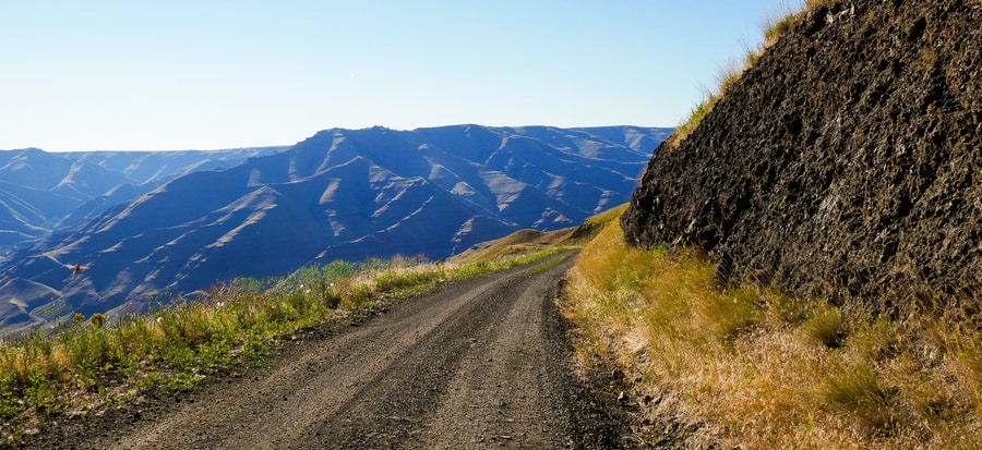
As with many far-flung places, traveling to Hat Point is about more than just the final destination. Along the entire journey from Imnaha to Hat Point, the road reveals spectacular views of the Imnaha Canyon and towering Wallowa Mountains.
In many ways, the road to Hat Point reminded me of the unpaved Steens Mountain Loop in southeast Oregon. It is truly a desolate place of rugged scenery and inhospitable terrain.
THE IMNAHA CANYON
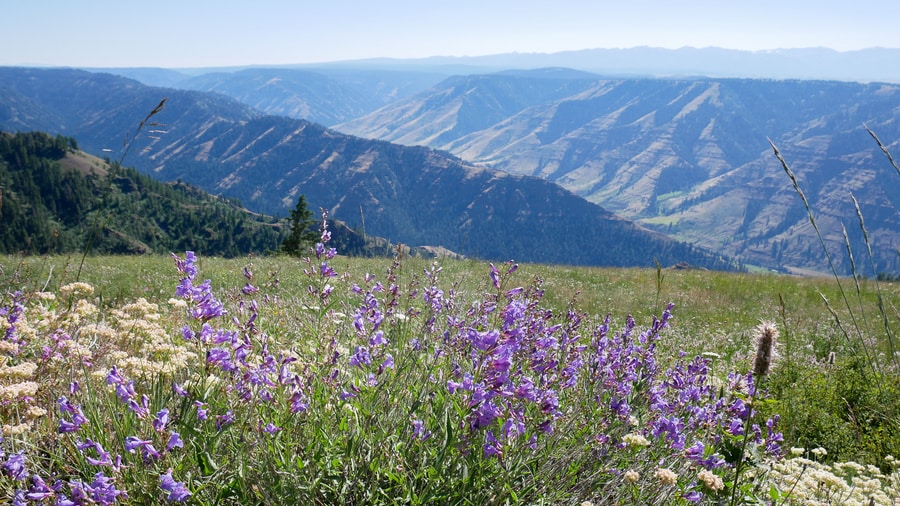
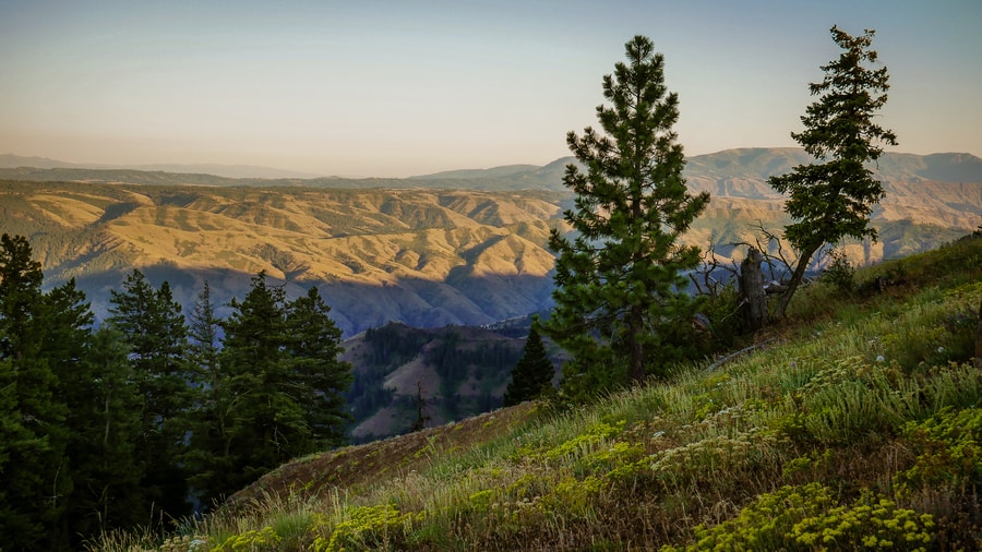
The road to Hat Point has a few different pullout areas that offer spectacular panoramic views of the Imnaha Canyon—a little-known gem that is every bit as scenic as nearby Hells Canyon.
The Imnaha River originates at an elevation of 8,000 ft, in the Wallowa Mountains. Over the course of 75 miles, it plunges nearly 7,000 ft to join the Snake River. The chiseled gorge that surrounds the river is accessible via the Hells Canyon National Recreation Area, the Eagle Cap Wilderness and the Hells Canyon Scenic Byway.
-
FIVE MILE OVERLOOK
Five Mile Overlook is the first scenic viewpoint along the Hat Point road. It sits at the crux of a hairpin bend, after a precipitous climb through wildfire-ravaged forest. The overlook contains a parking area and panel showing the seasonal cycles of the canyon.
In the distance, snow-covered peaks of the Eagle Cap Wilderness soar above the horizon.
From the Five Mile Overlook, we pressed on to the Horse Creek Viewpoint. I jumped out of the car to take a photo, but found that overgrown trees were blocking the views.
-
GRANNY VIEW OVERLOOK
About two thirds of the way down the road, Dan and I stopped at Granny View Overlook for some of the Imnaha River Canyon’s best panoramic vistas.
The Granny View Overlook has bathrooms, a parking area, and paved walking trails that lead to spectacular views of the river from above. A short wheelchair-accessible walkway cuts through wildflower-speckled grasslands and leads to a wooden panoramic platform that showcases the chiseled walls of the Imnaha River Valley.
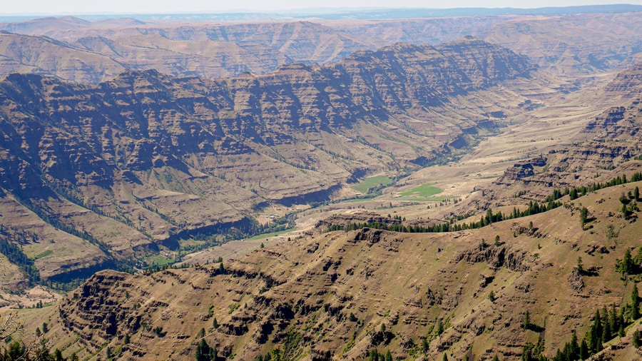
I might argue that the scenery from Granny View Overlook is the most impressive of the entire drive.
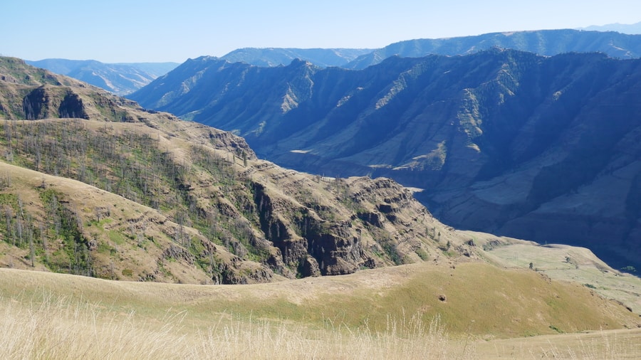
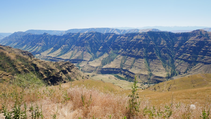
SNAKE RIVER CANYON AT HAT POINT
Hat Point sits at the end of a gravel road, overlooking the western edge of Hells Canyon. The scenic viewpoint gets its name from a cowboy who allegedly lost his hat to the canyon after a battle with an unruly horse.
It affords the best Hells Canyon views in all of Oregon.
As we gazed into the massive cavern from the Hat Point Overlook, it was difficult to believe that the Snake River flowed nearly 6,000 ft below where we were standing.
-
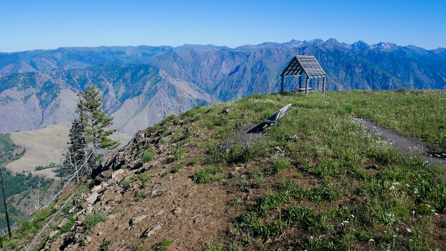
HAT POINT FIRE LOOKOUT TOWER
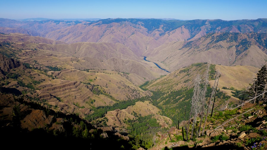
One of Oregon’s highest fire lookout towers (82 ft tall) crowns the Hat Point viewing area. It is among the only remaining fully functioning fire towers in the United States, and is largely open to the public. When we visited, we were permitted to climb to the penultimate level of the lookout tower. The tower’s highest vantage point is a working lookout station for park workers.
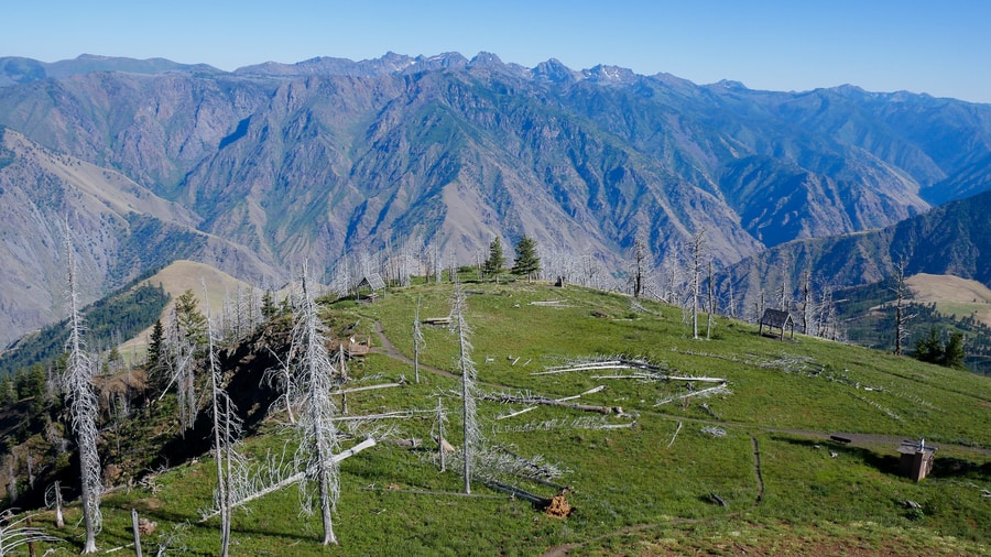
From the fire tower lookout at Hat Point, views of the Hells Canyon National Recreation Area unfold in all directions. On the Idaho Side, the Seven Devils Mountains Range peers ominously into the depths of Hells Canyon. Idaho’s Seven Devils Mountains— snow-capped in all but the hottest months—poke above the canyon rim like a set of crooked teeth.
To the west, Oregon’s Wallowa Mountains loom over the horizon.
THE HELLS CANYON SCENIC BYWAY IN OREGON
Though Hat Point offers the best views of Hells Canyon, the recreation area’s other renowned lookout lies along the Hells Canyon Scenic Byway.
Hells Canyon Scenic Byway follows a series of roads in a backwards ‘C’ shape, from La Grande to Baker City. In scenes somewhat reminiscent to Eastern Washington’s Palouse, it showcases the rolling hills of northeast Oregon. Beyond, the Wallowa Mountains form a stunning backdrop to the pastoral landscapes.
Ironically, the Hells Canyon Scenic Byway doesn’t provide many views of North America’s deepest river gorge. Nor does the canyon itself seem to be the focus of the drive.
Aside from the panorama at Hells Canyon Overlook, the byway mostly showcases hills of golden farmland, and soaring mountain peaks.
HELLS CANYON OVERLOOK
Hells Canyon Overlook offers the scenic byway’s only direct glimpse into the cavernous reaches of America’s largest canyon. It lies between Imnaha and Halfway, on a lonely forest service road that is only open during the late summer months.
The well-established Hells Canyon Overlook has interpretive signs and is easily accessible.
However, the views of the canyon walls—while still pretty—are not quite as dramatic as those of Hat Point.
VIEWING HELLS CANYON FROM BELOW
Properly exploring the Oregon side of Hells Canyon would require traveling along the Snake River and admiring the soaring canyon walls from down below (something I have not had the chance to do firsthand).
On the Oregon side, travelers can access the canyon via a road that leaves from the small community of Oxbow. Rafting expeditions and boat tours of Hells Canyon leave from the Pittsburg Landing in Idaho.
Because of the long distances between Hells Canyon’s attractions, Dan and I didn’t have time to visit the gorge from water-level.
BAKER CITY: GATEWAY TO HELLS CANYON
Baker City—a charming town of 6,000—is known as Eastern Oregon’s base camp. It sits sandwiched between the Elkhorn Mountains and the Wallowas, at the southern end of the Hells Canyon Scenic Byway.
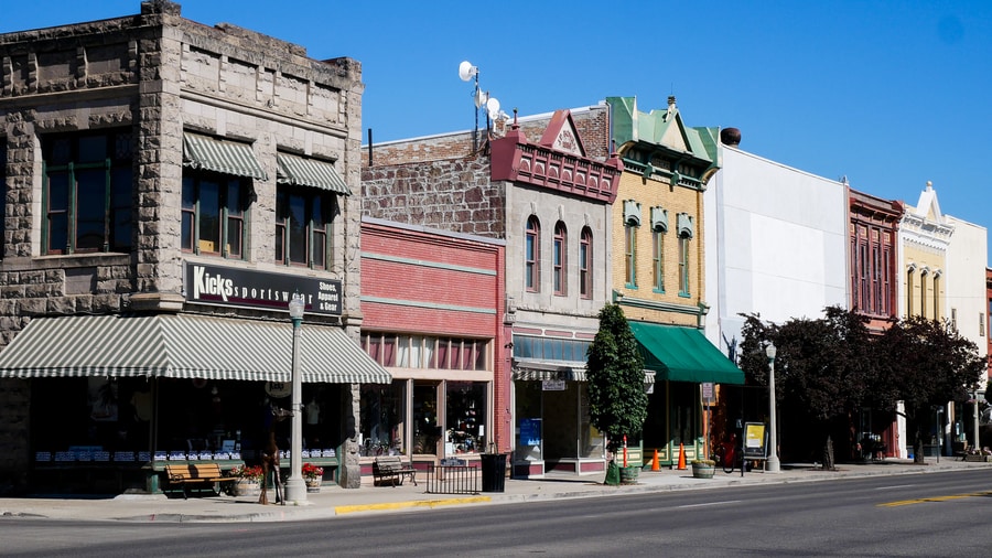
Baker City is a surprisingly interesting town. It was once the largest community between Portland and Salt Lake City. In its compact core, it has more than 100 historic buildings, its very own Carnegie Library, and a host of public art displays. Its picturesque main street is home to the Geiser Grand Hotel—a historic landmark that dates back to 1889.
-
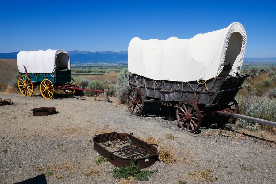
OREGON TRAIL INTERPRETIVE CENTER
The Oregon Trail Interpretive Center lies a few miles outside of Baker City. The center sits perched atop a hill, with sweeping views in all directions.
The interpretive center is administered by the National Parks Service. It offers exhibits, multi-media presentations, more than four miles of walking trails, and a glimpse into northeast Oregon’s early history. The area tells the story of the Oregon Trail’s pioneers, explorers, miners and settlers. The sprawling 500 acre site includes remnants of the historic Flagstaff Gold Mine, actual ruts carved by covered wagons in the 1800s, and magnificent vistas of the Elkhorn Mountains.
Since we visited during a global pandemic, Dan and I were not able to take advantage of the displays inside the visitor center.
Nonetheless, we enjoyed exploring the area’s pathways, reading informational plaques on gold-mining in the area, and imagining what it might have been like to come across Hells Canyon in the days of westward exploration.
****
Hells Canyon may not be a staple of most Pacific Northwest itineraries, but it is the type of place that attracts intrepid travelers with its promises of untamed landscapes and unexplored frontiers.
It doesn’t matter that its cavernous depths are filled with rattlesnakes. It doesn’t matter that the Seven Devils Wilderness—with names like She Devil, Twin Imps, and Devil’s Throne —loomed ominously overhead.
Despite its name and relative obscurity, Hells Canyon is beautiful.
In fact, with its lonely roads, its wide open vistas, its breathtaking scenery, its wildflower-strewn hillsides, and its tourist-free hiking trails, nature-lovers might even think they’ve come across Heaven.
_______________________________________
Did You Enjoy this Guide to Hells Canyon in Oregon? Pin It!