
Hiking in Santo Antão: Cape Verde’s Mountain Paradise
Santo Antão is, without a doubt, Cape Verde’s most visually striking island. Featuring chiseled canyons, terraced mountainsides, a vast network of hiking trails, and fertile river valleys, the vertical land mass is both hyperbolically beautiful and uniquely individual.
I’ve never seen a place quite like Santo Antão. Cape Verde’s emerald isle has a Caribbean-like vibe and a European flair. The island’s culture is an amalgam of Portuguese and mainland African influences. Its jaw-dropping scenery resembles that of a fantasyland. If Kauai’s Na Pali Coast were to have a child with Bali‘s rice terraces, I imagine the offspring would look something like Santo Antão.
SANTO ANTÃO TRAVEL LOGISTICS
Despite being an off-the-beaten-path destination, Santo Antão is logistically easy to navigate. The island is safe, its top attractions are well-connected with public transport, and its inhabitants are friendly.
Santo Antão may be one of Africa’s best hiking destinations, but its remote location means that it is still largely undiscovered. The island does not have an airport, nor does it have the infrastructure to handle cruise ships or mass tourism.
Still, a handful of intrepid adventure-lovers descend upon the island every year to take advantage of the most beautiful hikes in Cape Verde.
GETTING TO SANTO ANTÃO
Since Santo Antão does not yet have an airport, most international visitors arrive at the Cesaria Evora Airport, on the nearby island of São Vicente. Daily flights from Lisbon connect São Vicente to Europe, while a ferry system links the island with other population centers around the country.
Mindelo, the largest city on São Vicente, lies only an hour by boat from Santo Antão. It is the cultural capital of Cape Verde and the country’s second most populous city.
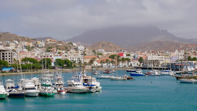
Two ferry companies make the daily journey between Mindelo and Santo Antão. The crossing takes approximately one hour and costs €8 each way.
After purchasing our ferry tickets at the harbor, Dan and I had about an hour and a half to enjoy São Vicente. Instead of waiting at the ferry terminal, we lugged our bags to the white sands of Praia da Laghina. There, we enjoyed a lovely lunch of grilled octopus at the Kalimba Beach Club, while watching the turquoise waves lap gently against the powdery beach.
GETTING AROUND SANTO ANTÃO
Ferries from São Vicente arrive in the town of Porto Novo, on the south side of Santo Antão. From Porto Novo, aluguers provide onward transport to the most popular towns on the island.
While it is possible to rent a car at Santo Antão’s ferry terminal, aluguers are the island’s main form of transport. Like combis in South Africa, trotros in Ghana or mashrutkas in Georgia, aluguers are minibuses that have designated routes and leave when full. The aluguers in Santo Antão travel along the coastal road and venture into some of the more populous valleys of the island’s interior.
For travel between the main towns on the island, fares generally cost €1-4.
WHERE TO STAY ON SANTO ANTÃO
During our four days on Santo Antão, Dan and I split our stay between Sintanton Trekking in Ponta do Sol, and Casa Maracuja in the Paul Valley. Each location had its pros and cons, depending on our activities for the day.
Sintanton Trekking is a budget accommodation option that specializes in providing information on hiking in Santo Antão. Its location in Ponta do Sol makes it a convenient place to stay for those attempting the coastal walk between Cha da Igreja and Ponta do Sol.
However, though we enjoyed the hotel’s favorable price and optimal location, we didn’t find the hiking advice to be particularly helpful. Had we had another night in the area, we would have likely booked a room at Kasa Tambla.
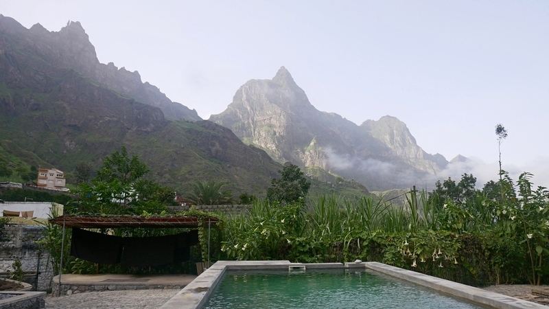
Since Dan and I wanted to spend our remaining nights immersed in nature, we looked at accommodation in the Paul Valley for the second half of our Cape Verde vacation.
Our first choice accommodation—Casa Cavoquinho—was sold out for the week. So instead, we settled on the nearby Casa Maracuja, and couldn’t have been happier with our choice. With its swimming pool, favorable price, mountain views and clean bungalow-style rooms, we felt as though we were spending a few days in paradise.
WHERE TO EAT IN SANTO ANTÃO
Though we admittedly didn’t have the time to sample many of the restaurants on Santo Antão, we thoroughly enjoyed eating dinner at the lovely Caleta Restaurant in Ponta do Sol. The alcohol-free establishment serves delicious and fresh local fare, to a soundtrack of crashing waves.
While in the Paul Valley, we primarily ate at Casa Maracuja. The restaurant/hotel has a rather limited menu, but the grilled octopus was some of the best I’ve ever tasted.
POPULAR HIKES IN SANTO ANTÃO
Trails and scenic roads crisscross Santo Antão’s ruptured canyons and sheer mountainsides, making the island one of the top hiking destinations in Africa.
Unlike the touristy Cape Verdean islands of Sal and Boa Vista, Santo Antão doesn’t boast stretches of sand that are suitable for beach-lounging. It certainly isn’t a typical island retreat, nor is it an overrun party destination that caters to snowbirds from Europe. Instead, the mountainous wonderland—with its vast network of trails—is a playground for hikers and lovers of the outdoors.
Though aluguers traverse much of Santo Antão, the best way to explore the island is on foot. During our trip to Cape Verde, Dan and I hiked some of the most beautiful trails on Santo Antão.
And while our itinerary was in no way exhaustive of Santo Antão’s diverse offerings, it gave us a sampling of the island’s rustic appeal and gobsmacking beauty.
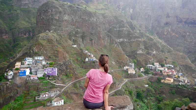
COASTAL HIKE FROM CHA DA IGREJA TO PONTA DO SOL
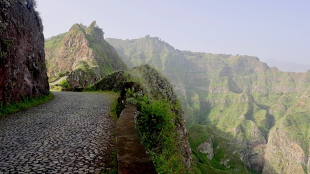
On our first full day in Santo Antão, we set out on a popular coastal trail that connects Cha da Igreja with Ponta do Sol. The hike hugs the island’s northeastern coast and passes through villages with no access to paved roads. From this winding coastal trail, views of the towering cliffs and terraced valleys are some of the most impressive on the island.
Unfortunately, public minibuses to Cha da Igreja are either infrequent or entirely nonexistent. In order to avoid waiting around all day for the possibility of catching a public aluguer, we spent €25 and hired a private driver to take us to Cha da Igreja.
During our drive to Cha da Igreja, clouds hung to the tops of the mountains and drifted into the valley. They concealed the mountain peaks and covered our surroundings in a translucent layer of film. The limited visibility made it frustrating to photograph the scenery, but it did not take away from the area’s beauty.
Santo Antão’s spectacular coastal hike is approximately 11 miles long and takes most of the day to complete. From Cha da Igreja, we followed the well-marked coastal path past Cruzinha, Formiguinhas, Corvo and Fontinhas.
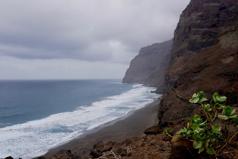
This ancient coast—with its steep bluffs and rugged cliffs facing the Atlantic—is absolutely breathtaking. The path clings to the winding contours of age-old lava flows, past sweeping black sand beaches and abandoned villages.
Occasionally, the path detours inland, past deep valleys populated by tiny villages.
The first village along our trek was the small isolated community of Formiguinhas. There, we stopped for a lunch of soggy fries, before cutting inland, toward the tiny hamlet of Corvo.
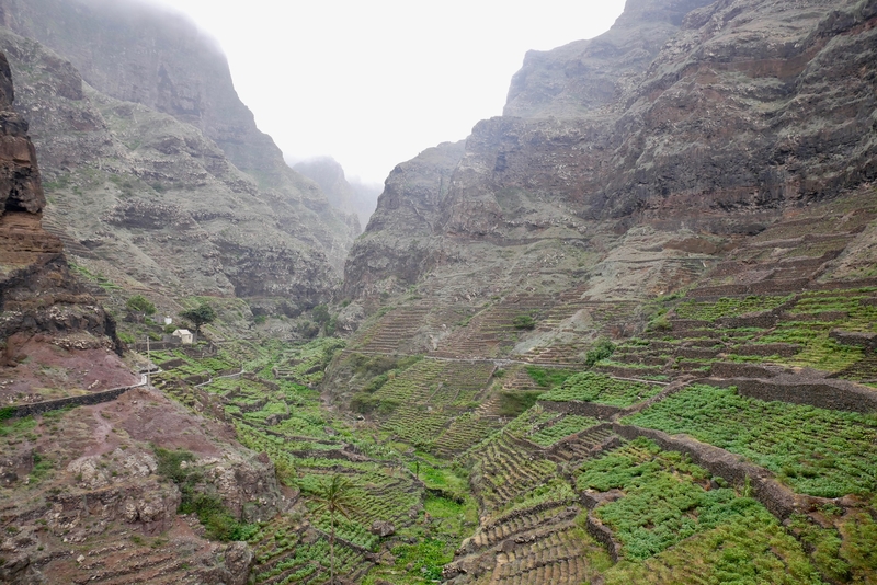
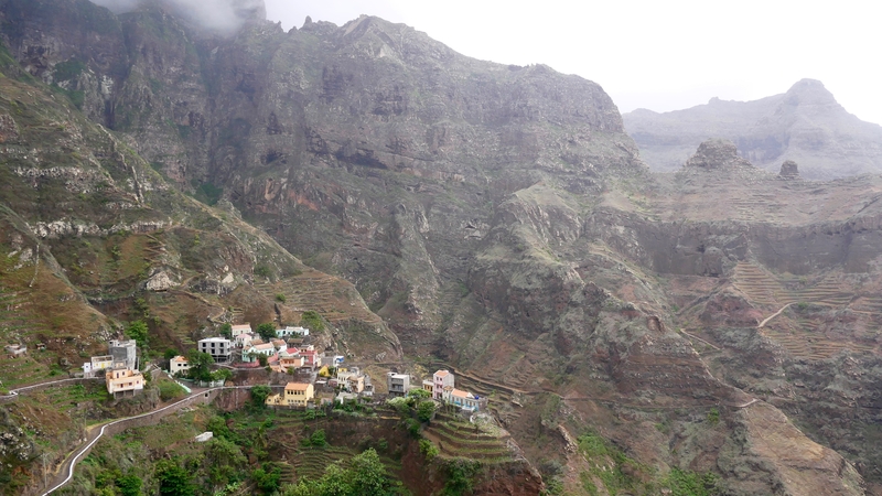
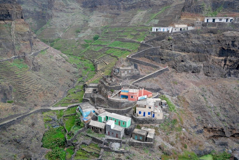
Had we not continued to Fontinhas, I would have thought Corvo to be the prettiest town on Santo Antão. The trail clings to a mountainside, overlooking a fertile river valley that showcases some of the best examples of the island’s terraced farmlands.
The trail from Corvo to Fontinhas is among the steepest segments of the trek. Along the way, its switchbacks contain small placards illustrating the stations of the cross.
At the top, views into two separate river valleys provide some of the most breathtaking 360 scenery I’ve ever seen.
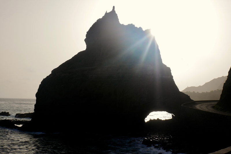
Fontinhas—often regarded as the prettiest village in Santo Antão— is the most photographed village in Cape Verde. Unlike Corvo and Formiguinhas, it is accessible by car from Ponta do Sol.
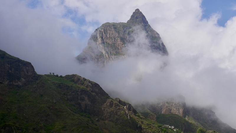
RIBEIRA GRANDE TO THE XOXO VALLEY
On the day after our lovely coastal hike, Dan and I took a series of aluguers from Ponta do Sol to our guesthouse in the Paul Valley. We had originally intended to do some hiking along the trails near our guesthouse, but thick clouds and rainfall obscured our views.
Knowing that the weather was better in the valleys, we dropped off our bags and headed back down the hill to Ribiera Grande. From there, we chose to walk along the Ribiera Torre, toward the village of Xoxo.
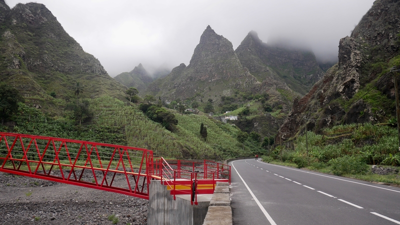
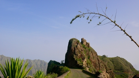
Xoxo’s claim to fame is a spire-like rock outcrop that pierces the sky. From Ribiera Grande, aluguers travel down the Ribiera Torre Road. The road follows a river and passes by quaint farms and a series of crimson-colored bridges. The lightly-trafficked road is the perfect place to take a leisurely afternoon stroll, while enjoying killer views.
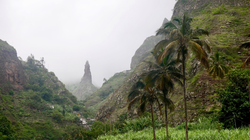
Before reaching the needle-like peak of Xoxo, a pain in my abdomen forced us to turn back.
From what I could see, however, the Ribeira Torre is one of the island’s prettiest roads.
COVA CRATER AND THE PAUL VALLEY HIKE
Our Santo Antão vacation didn’t exactly go according to plan. On our third day in Santo Antão, my discomfort from the previous day intensified. As a result, I spent the majority of the following day in bed.
Luckily, Casa Maracuja’s location amongst the stunning greenery of Paul, meant that the day wasn’t a total wash. We spent the morning enjoying the views by the pool. In the afternoon, I mustered the energy to complete a short three mile hike near our guesthouse.
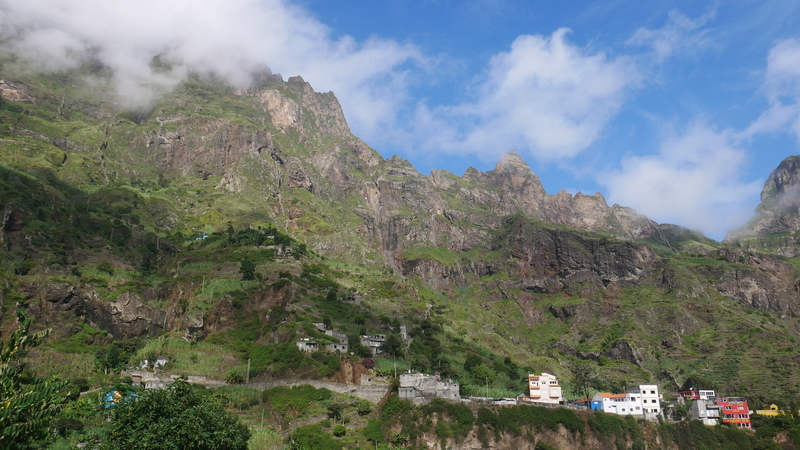
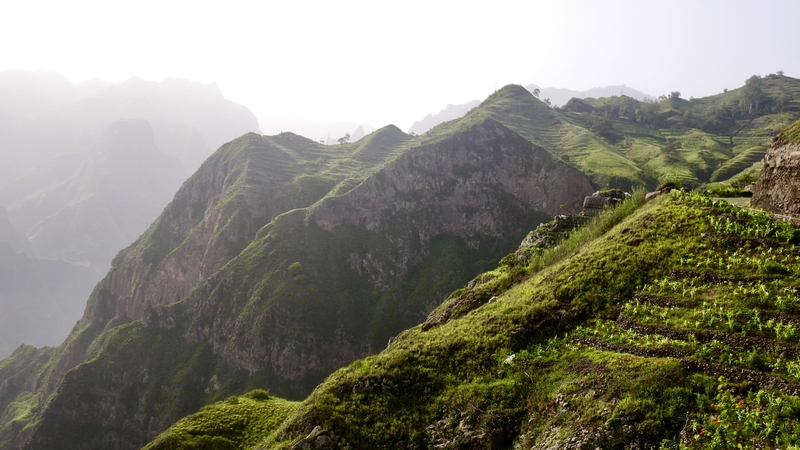
The Paul Valley is a true gem. Photos do not do justice to the village-speckled mountainsides and their vertiginous cliffs.
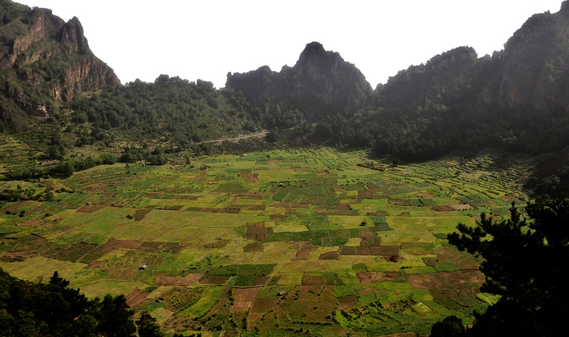
The Paul Valley hike is one of the top things to do in Santo Antão, and I couldn’t imagine leaving the island without soaking in the views from the top of Cova Crater—a volcanic caldera that houses patchwork fields of maize and beans.
In order to best experience the area, Dan and I chose to extend our stay on Santo Antão and dedicate an entire day to the Paul Valley trek.
Heeding the advice of our guesthouse staff, we hired a driver to take us along the island’s old road, to the Cova Crater. From there, we soaked in views from Delgadihno Ridge, and began the knee-breaking downhill journey through the lushest valley on the island.
The popular Paul Valley hike begins at the Cova Crater and continues down the mountain to Ribiera Grande. The steep hike from the Cova Crater is among the most stunning I’ve experienced to date.
Past the ridge, a trail winds along the valley’s terraced slopes, descending past small homesteads and guava plantations.
Casa Maracuja sits halfway down the Paul Valley, near the trail’s junction with the vehicular road.
Since I was still feeling a bit sick at this point in our trip, we decided to cut the hike short and finish once we reached our guesthouse.
SCENIC DRIVES IN SANTO ANTÃO
While hiking is undoubtedly the best way to explore Santo Antão, driving along the island’s interior road is one of the top things to do on the island. Santo Antão has two main roads: a new ‘direct’ coastal route that travels between Porto Novo and Ribiera Grande, and a vertigo-inducing interior road that winds past the village of Corda.
-
DRIVING THE NEW ROAD IN SANTO ANTÃO
Everything I’d read online suggested that, comparative to the old mountain road, the newly-constructed coastal route had little to see. Yet, we found the coastal connector to be anything but boring. In fact, had we not chosen to drive the interior road on our last day in Santo Antão, I might have thought the coastal road to be the most spectacular on the island.
The coastal road in Santo Antão begins in Porto Novo and weaves past barren windswept valleys, toward the water. When it reaches the coastline, it hugs the island’s towering cliffs and showcases dramatic coastal views.
Dan and I were glued to the window of the aluguer throughout the entirety of the ride. If this was the ‘boring’ road, we knew that we were in for a treat.
- DRIVING THE RUA DA CORDA
Dan and I had the opportunity to travel along the island’s historic interior road, en-route to the starting point of the Paul Valley hike. Since the road travels along sparsely-populated mountain ridges, we were unable to find public aluguers for the journey. As with our trip to Cha da Igreja, we hired a private driver to take us to the start of the trail.
For the views alone, hiring a driver to take us along the Rua da Corda was certainly worth the hefty price tag.
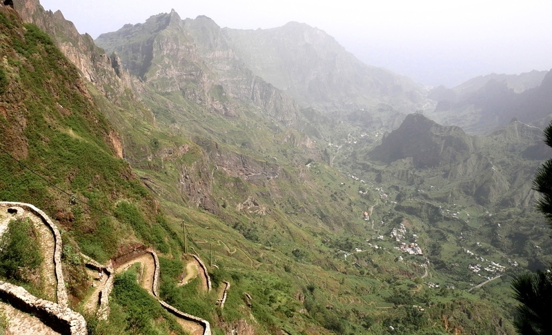
The scenic drive travels between Porto Novo and Ribiera Grande, via the small farming village of Corda. As we ascended along the cobblestone road, I couldn’t believe my eyes. (In all honesty, when I first saw many things on Santo Antão, I couldn’t believe my eyes.) The road cuts north, through some of the island’s most fertile valleys. It snakes along steep slopes and teeters atop the volcanic ridges of the island.
The views along the drive are sensational and worth every penny of the €40 we relinquished in order to make the journey.
I only wish we had the right lighting and weather conditions for my photos to do the area justice.
***
Santo Antão is a wonderland of hyperbolic beauty and jaw-dropping vistas. Drenched in a blanket of green, it is the only island in the country that puts the verde in Cabo Verde.
Yet unlike other pristine islands around the world that have attracted unfettered development, Santo Antão remains a small-scale tourist destination that caters to trekking enthusiasts.
It remains to be seen if this will change. As sun-seekers from Europe continue to discover islands beyond Mallorca and the Canaries, I expect Cape Verde to welcome a larger influx of tourists. The island chain is simply too beautiful to remain a secret.
However—even if Santo Antão draws larger crowds with its new airport and increased exposure— I don’t foresee the island losing its unique appeal. In the same way that Saba has managed to escape cookie-cutter developments due to its vertical landscape and lack of notable beaches, so too do I believe that Santo Antão has the potential to retain its charm.
And I hope it does. Because this fantasyland of soaring emerald peaks and rugged windswept coastline is truly unlike any other place I’ve ever been.
___________________________________________
Did you enjoy this recap of the best things to do on Santo Antão? Pin it!


